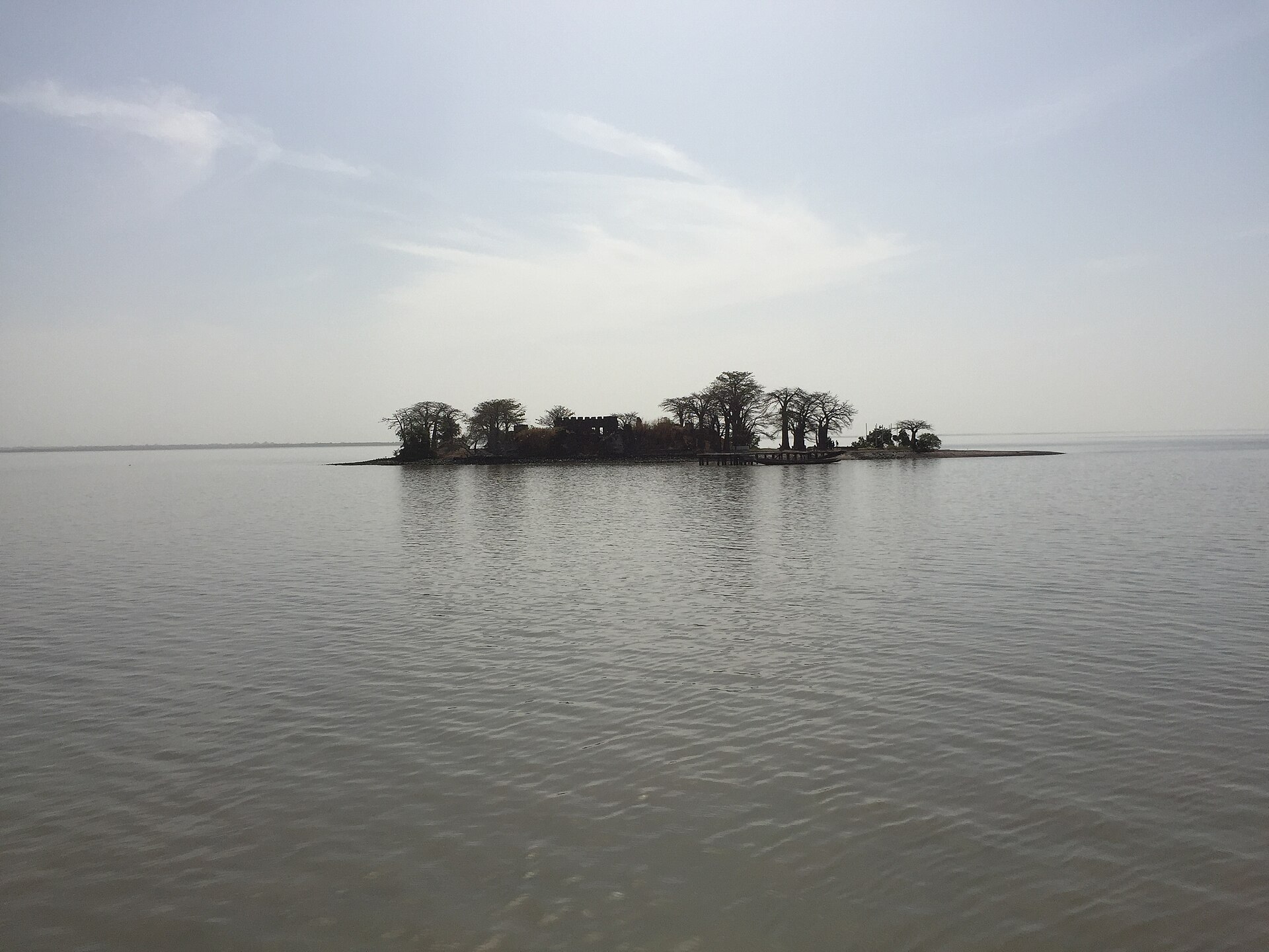
In the wide brown waters of the Gambia River, some thirty kilometres upstream from the Atlantic, lies a tiny island so small you could walk around its ruins in a few minutes. It is a scrap of land crumbling slowly into the current, shaded by ancient baobab trees, scattered with the broken stones of an old fort. Yet this modest island, now called Kunta Kinteh Island, carries one of the heaviest histories anywhere on the African coast, for it was a gateway of the transatlantic slave trade.
For centuries this speck of land was fought over by one European power after another, its little fort changing hands again and again, because whoever held it controlled access to the river and the trade that flowed along it. Portuguese, Courlanders, Dutch, French, and English all planted their flags here, and through their forts passed gold, ivory, and, most harrowingly, enslaved human beings bound for the plantations of the Americas.
In this guide you will follow the island’s whole story: its naming by early explorers, the strange episode when a small Baltic duchy built a fort here, the long tug-of-war between European powers, its central and painful role in the slave trade, its worldwide fame through Alex Haley’s Roots, and its recognition as a UNESCO World Heritage Site. This is a place to visit with a thoughtful heart, and understanding its history is the first step.
Before you read on, a word about how to approach this island. Unlike a castle you visit for its architecture or a palace you admire for its grandeur, this is first and foremost a place of memory and mourning. Its ruins are modest, but the history they hold is vast and heavy. Coming to understand it is less about ticking off sights and more about bearing witness, and that spirit shapes everything that follows in this guide.
In This Article
- A Tiny Island, a Great River
- Explorers and the Naming of the Island
- The Baltic Duke Who Built a Fort in Africa
- A Fort That Changed Hands Again and Again
- The Fort and the Atlantic Slave Trade
- From Slave Fort to Anti-Slavery Base
- Kunta Kinte and the Power of Roots
- Walking Among the Ruins
- An Island Slowly Vanishing
- The Island and Its Related Sites
- A World Heritage Site of Memory
- Juffureh and the Living Memory
- Visiting Kunta Kinteh Island
A Tiny Island, a Great River
To understand why anyone fought over such a small island, you have to understand the river. The Gambia is one of West Africa’s great waterways, navigable far into the interior, and for European traders it was a highway into a continent whose overland routes they could not control. A ship could sail up the Gambia and reach markets deep inland, and the island sat astride that route like a tollgate.

Positioned around thirty kilometres from the river’s mouth, the island commanded the passage upstream. A fort here could control who came and went, tax the trade, and provide a defensible base far safer than any post on the mainland, where local African rulers held the real power. For a European power with more ambition than manpower, a fortified island was the ideal foothold.
That is the key to the island’s whole turbulent history. It was never valuable for its size, which is minuscule, but for its position. Control of this one small rock meant a share in the lucrative commerce of the Gambia, and that is why it was seized, lost, and seized again by one power after another across more than two centuries of rivalry.
The dynamic between European traders and African powers on the river is crucial to grasp. The Europeans on their island fort did not rule the surrounding land; they operated with the permission and through the cooperation of local African rulers, such as the King of Barra, who controlled the mainland and could grant or withhold access. The fort was a foothold, not a conquest, and that balance of power shaped everything that happened here.
The Gambia River itself is a remarkable feature, a long ribbon of water almost entirely surrounded by the country that takes its name, cutting deep into the West African interior. For centuries it functioned as a natural corridor of trade and communication, and control of key points along it, above all this island near its mouth, translated directly into commercial and strategic power for whoever could hold them.
Explorers and the Naming of the Island
The island’s recorded history reaches back to the middle of the fifteenth century, when the first European ships nosed up the Gambia. In the 1450s explorers sailing in the service of Portugal reached the island, and according to tradition it gained the name St Andrew’s Island after a sailor named André who was buried there, an early sign of how the story of this place would be written in the coming and going of outsiders.

The Portuguese established themselves in the region, setting up a settlement on the nearby riverbank and beginning the long European involvement with the Gambia trade. For a couple of centuries the pattern was set: the island and its surroundings became a meeting point between African societies and European traders drawn by the wealth that moved along the river.
These early names and settlements are worth remembering because they mark the beginning of a process that would reshape the whole Atlantic world. What started as tentative trading contacts in the fifteenth century would grow, over the following centuries, into one of the largest forced migrations in human history, and this little island would sit close to the heart of it.
Each successive European name laid on the island, St Andrew’s, Jacob, James, and finally Kunta Kinteh, marks a different chapter of its history, almost like the rings of a tree. To trace the island’s names is to trace the whole sweep of its story, from tentative Portuguese exploration through the era of competing colonial powers to the modern reclaiming of the site in the name of the enslaved.
The nearby mainland settlements grew up in tandem with the island fort, and the trade drew together a whole community of European agents, African traders, interpreters, and labourers around the business of the river. This was a genuine frontier zone of encounter, where cultures met and mingled, and where the profits of commerce were pursued alongside the human costs that would come to define the place in later memory.
The Baltic Duke Who Built a Fort in Africa
One of the most surprising episodes in the island’s history involves a small European state you might not expect to find in West Africa: the Duchy of Courland, a minor Baltic power in what is now Latvia. In 1651 settlers from Courland built a fort on the island, naming it Jacob Fort after their ruler, Duke Jacob Kettler, an ambitious prince with dreams of overseas colonies.

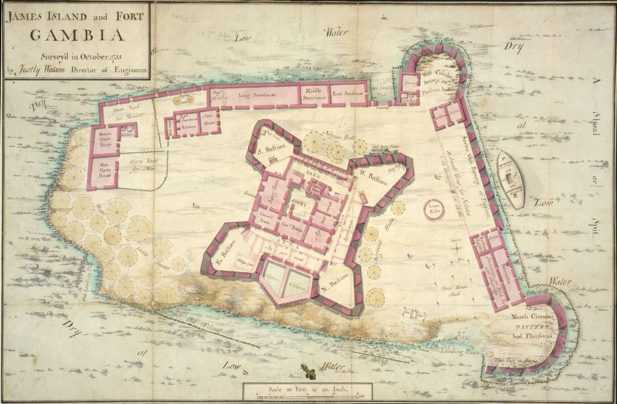
It was an audacious bid for a tiny state to join the great powers in the scramble for African trade. The Courlanders fortified the island with a rectangular fort and corner bastions, established a settlement complete with pastors, and even mounted expeditions in search of gold. For a brief moment this obscure Baltic duchy held a foothold on the Gambia, a genuine curiosity of colonial history.
The Courland venture did not last. Small and far from home, the settlement was vulnerable, and within a decade the island had slipped from Courland’s grasp into the hands of stronger rivals. But the episode is a vivid reminder of how many different European powers, large and small, were drawn into the contest for African trade, and how far some were willing to reach in pursuit of it.
Duke Jacob Kettler’s overseas ambitions extended beyond the Gambia, for his little duchy also attempted a colony in the Caribbean. That a small Baltic state could reach so far speaks to how the promise of colonial wealth fired the imagination of seventeenth-century Europe. The Gambian venture, though short-lived, remains one of the more astonishing footnotes in the whole history of European expansion overseas.
The Courlanders were eventually squeezed out by a combination of their own weakness and the ambitions of larger rivals, but not before leaving their mark on the island’s tangled history. Their brief presence is a striking illustration of how the age of exploration drew in participants from the most unexpected corners of Europe, all chasing the same dream of the wealth that overseas trade seemed to promise.
A Fort That Changed Hands Again and Again
After the Courlanders, the island entered a dizzying period of changing ownership that reflected the wider European wars and rivalries of the age. The Dutch West India Company took control for a time, a French privateer briefly seized it, and then, in 1661, the English captured the fort, beginning the long period of English and later British involvement that would define the island’s most notorious era.

The English renamed the stronghold Fort James, after the Duke of York who would later become King James II, and placed it under a series of chartered trading companies, including the famous Royal African Company. But even English control was far from secure. The French captured the fort again in the 1690s, and over the years it was repeatedly damaged, rebuilt, and contested as the European powers fought for dominance of the trade.
This constant turnover tells you everything about how the island was valued. No one held it out of sentiment; they held it for profit, and they fought for it whenever the balance of power shifted. The battered, much-rebuilt ruins you see today are the physical record of that long struggle, a fort that was destroyed and raised up again more times than its defenders could easily count.
Each time the fort changed hands it was typically damaged or destroyed and then rebuilt by the new occupiers, which is why so little of any single original structure survives. The ruins are a palimpsest, layers of Courland, Dutch, English, and French building and rebuilding overlaid on one another, a physical record of the endless contest for this strategic scrap of land in the river.
Life in the fort for its European garrison was often grim, shadowed by disease, isolation, and the ever-present threat of attack. Tropical fevers carried off many of the soldiers and traders stationed here, and the fort’s small, vulnerable community depended heavily on supplies and goodwill from the mainland. It was a hard, precarious posting, and the human cost fell on all who lived and worked in its shadow.
The Fort and the Atlantic Slave Trade
There is no honest way to tell the story of this island without confronting its central role in the trade in human beings. Under the English trading companies, Fort James became a key point in the transatlantic slave trade, a place where enslaved Africans, brought from the interior, were held before being loaded onto ships bound across the ocean to the plantations of the Americas.

The fort dealt in gold and ivory too, but it was the trade in people that made it infamous and that gives the ruins their terrible weight. For the countless individuals who passed through this place in chains, the island was the last piece of African soil they would ever touch, the threshold between their homeland and a life of bondage across the sea. That reality hangs over every stone.
Visiting the island today, you are walking through a site of profound human suffering. It demands a different kind of attention than a mere castle or palace, a willingness to remember the individual lives caught up in this vast machinery of exploitation. The beauty of the river and the baobabs coexists with the memory of one of history’s greatest crimes, and both truths have to be held together.
The scale of the transatlantic trade that passed through West African forts like this one is almost impossible to comprehend. Over the centuries of its operation, millions of Africans were forcibly shipped across the ocean, and each of the coastal forts and islands played its part in feeding that vast and pitiless system. This island was one node among many, but for those who passed through it, it was the whole world ending.
It is worth naming plainly what these forts were for in their darkest function. They were holding places, where human beings stripped of their freedom were kept, guarded, and made ready for sale and shipment. Behind the neutral language of trade lay chains, dungeons, and the deliberate breaking of families and lives. Confronting that reality without flinching is part of what it means to visit this island honestly and with respect.
From Slave Fort to Anti-Slavery Base
The island’s story took a striking turn in the early nineteenth century. In 1807 Britain passed its act abolishing the slave trade, and the very same fortifications that had served the trade were now turned against it. New defences were built in the area to help suppress the traffic in enslaved people, an attempt to police the river and intercept the slave ships that continued to operate illegally.

There is a deep irony here that is worth sitting with. A place that had for so long been an instrument of the slave trade became, at least in part, a tool for its suppression, as Britain shifted from being one of the trade’s greatest practitioners to one of its policemen. The transformation did not undo the centuries of suffering, but it marked a genuine change in the island’s role.
By around 1870 the various forts and stations in the area were abandoned, their military and commercial purpose finally exhausted. The long era of European fortresses on the Gambia was over, and the island was left to the river, the birds, and the slow work of erosion, its dramatic history seemingly at an end until the twentieth century gave it a powerful new meaning.
The suppression campaign was long, difficult, and incomplete, for the illegal trade persisted for decades after abolition as smugglers sought to evade the patrols. The forts and batteries built to stop them are a reminder that ending the slave trade was not a single moment but a prolonged struggle, waged in part on this very river, against those determined to continue profiting from human misery.
The story of abolition on this river is a reminder that history can turn, and that even deeply entrenched systems of exploitation can be challenged and, eventually, dismantled. The transformation of these fortifications from instruments of the trade into tools against it, however partial and belated, marks one of the more hopeful notes in an otherwise sombre history, and it is part of what visitors can reflect on here.
Kunta Kinte and the Power of Roots
For much of the world, this obscure island became famous through a single extraordinary book. In the 1970s the American writer Alex Haley published Roots, tracing his family’s history back to an ancestor named Kunta Kinte, said to have been captured near the Gambia River and carried into slavery in America. The book, and the television series based on it, became a global phenomenon.
Haley’s account connected this small African island and the nearby village of Juffureh to the personal story of millions in the African diaspora seeking to recover a heritage that slavery had tried to erase. Whatever debates historians have had about the details, the emotional and cultural impact of Roots was immense, transforming the island into a place of pilgrimage and remembrance.
In recognition of this connection, the island was officially renamed Kunta Kinteh Island in 2011, replacing the old colonial name of James Island. The change was itself a powerful act, reclaiming the site from the names of European dukes and kings and dedicating it instead to the memory of the enslaved Africans whose suffering is the island’s true and enduring story.
The phenomenon of Roots also sparked a broader movement of heritage tourism and genealogical searching among the African diaspora, as people inspired by Haley’s example sought to trace their own origins. The island and Juffureh became symbols of that yearning to reconnect across the rupture of slavery, and they continue to draw those seeking to understand and honour their ancestry to this day.
Historians have debated how precisely Haley’s genealogical claims can be verified, and that scholarly discussion is legitimate. But it should not obscure the deeper truth the book conveyed, that behind the abstract statistics of the slave trade lay real individuals, families, and communities torn apart. Roots gave a human face to an almost unimaginable collective tragedy, and that achievement is why its impact endured.
Walking Among the Ruins
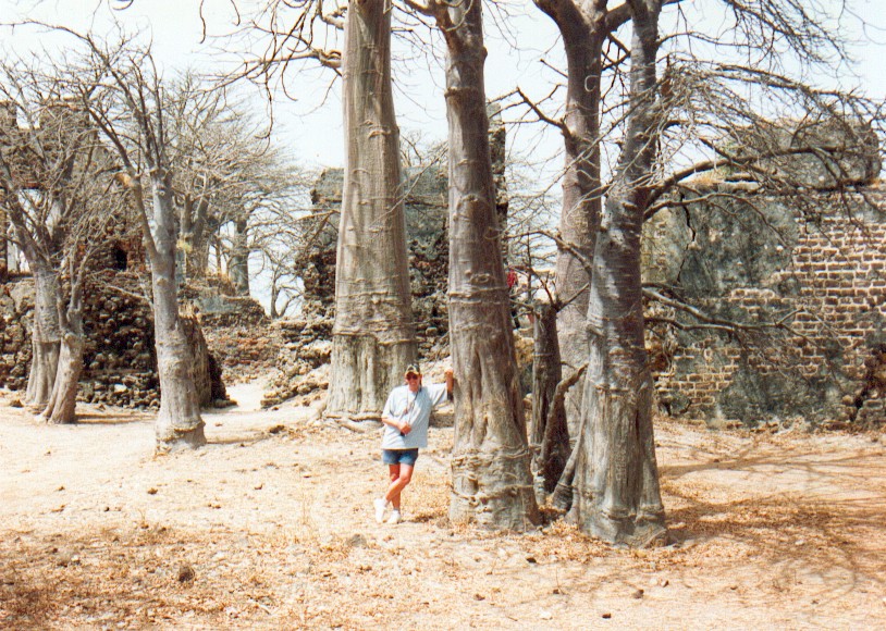
What actually survives on the island today is a haunting scatter of ruins. The remains of the old fort, weathered walls and foundations of British-era buildings, stand among the trees, along with the vestiges of a jetty and a few great baobabs that have witnessed the whole drama. It is a small site, and much of it has been lost, but what remains is deeply evocative.

The ruins are fragmentary because the island has been battered by time, war, and above all the river itself. Centuries of erosion have eaten away at the land, so that the island today is only a fraction of its former size, and some of the old structures have simply vanished into the water. In a sense the site is still disappearing before our eyes, which lends any visit a certain urgency.
Wandering among these broken stones, you are struck by the contrast between the smallness of the physical remains and the enormity of what happened here. There is no grand architecture to admire, no soaring towers, only humble ruins in a beautiful, melancholy setting. Yet that very modesty feels appropriate to a place whose importance lies not in its buildings but in its human history.
The great baobab trees deserve special mention, for these massive, ancient trees have stood through much of the island’s dramatic history and lend the ruins a timeless, almost sacred atmosphere. Gnarled and enormous, they seem to stand as silent witnesses, and for many visitors they become as memorable and moving as the fort itself, living monuments to all that the island has endured.
Interpretive efforts on and around the island aim to help visitors read these sparse remains and understand what once stood here and what took place. Without such guidance the ruins can seem almost too modest for their reputation, but with context they come alive, and the imagination can begin to reconstruct the fort, the ships, and the human drama that once filled this now quiet and shrinking scrap of land.
An Island Slowly Vanishing
One of the most poignant facts about Kunta Kinteh Island is that it is physically shrinking. The relentless action of the Gambia River has eroded the island down to a small fraction of the size it once was, and the process continues. Protective measures have been attempted to slow the loss, but the river is a powerful adversary and the little island remains under threat.

This erosion is more than a practical conservation problem; it carries a certain symbolic force. A place that holds such vital historical memory is, quite literally, washing away, and with it the physical evidence of the events it witnessed. There is a race against time to document, protect, and interpret the site before more of it is lost to the water.
For the visitor, the erosion adds a layer of urgency and reflection to the experience. You are seeing something that may not endure, a fragile survivor of a monumental history. It is a reminder that heritage is not automatically permanent, and that places of memory require active care if they are to be passed on to those who come after us.
Efforts to stabilise the shoreline and protect what remains reflect a wider challenge facing heritage sites across the world as they contend with environmental threats. Here the threat is immediate and visible, the river gnawing at the land year by year, and it lends the ongoing conservation work a real poignancy. Saving the island is, in a sense, saving a piece of the world’s shared memory.
The Island and Its Related Sites
The UNESCO listing recognises not just the island alone but a cluster of related sites along this stretch of the Gambia, and understanding them together gives a fuller picture. Nearby lie the village of Juffureh, famous through its association with the Kunta Kinte story, and the remains of other European settlements and fortifications connected to the trade along the river.
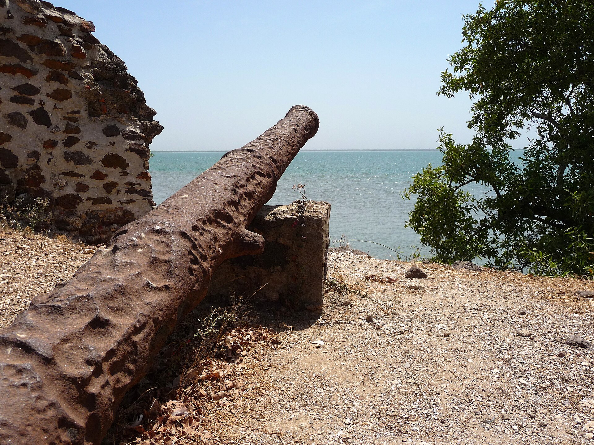
These related sites together tell the story of the encounter between Africa and Europe on the Gambia, from the earliest contacts through the height of the slave trade to the era of its abolition. The forts and batteries built to suppress the illegal traffic in the nineteenth century are part of the ensemble too, so the whole area charts the trade’s long and terrible arc from beginning to end.
Seeing the island as one element in this wider landscape enriches a visit enormously. The little ruined fort in the river makes fullest sense when understood alongside the villages, settlements, and later anti-slavery defences around it, all bound together by the great river that made this place both valuable and tragic across so many centuries.
The inclusion of multiple sites in the listing reflects a modern understanding that history is best preserved as a landscape, not a single monument. By protecting the island together with the villages, settlements, and later batteries, the designation safeguards the full story of the trade along this river, from the arrival of the first Europeans to the eventual struggle to bring the traffic in human beings to an end.
Walking or travelling between these connected places, you begin to feel the geography of the trade as the people of the time would have known it, the river as highway, the island as gateway, the villages as the human hinterland. That embodied sense of the landscape is something no book can quite convey, and it is one of the deepest rewards of making the journey to see the sites in person rather than reading about them from afar.
A World Heritage Site of Memory
In 2003 the island and its related sites were inscribed on the UNESCO World Heritage List, under a designation that recognised their outstanding importance as testimony to the encounter between Africa and Europe and to the history of the slave trade. It placed this small, eroding island among the officially recognised treasures and memorials of humanity.

The heritage listing frames the site above all as a place of memory. Its value lies not in architectural splendour but in what it represents: the meeting of continents, the commerce that flowed along the river, and the immense human tragedy of the transatlantic slave trade. It stands as a monument to remembrance and, implicitly, as a warning drawn from one of history’s darkest chapters.
For the Gambia, one of Africa’s smallest nations, the site is a source of profound significance, drawing visitors from across the world, especially from the African diaspora, who come to connect with a difficult shared past. UNESCO recognition affirms that this history belongs not just to the Gambia but to all humanity, and that it must be preserved and remembered.
World Heritage status also brings responsibilities and opportunities, from conservation funding to the challenge of interpreting a painful history for visitors from many backgrounds. Presenting such a site with honesty and sensitivity, neither sanitising the past nor reducing it to spectacle, is a demanding task, and one that the custodians of this island continue to grapple with as they welcome the world to remember.
The designation sits within a broader UNESCO effort to recognise sites connected to the slave trade and to the memory of slavery around the Atlantic world, from the forts of Ghana to the ports of the Americas. Seen in that light, Kunta Kinteh Island is one point in a global geography of memory, linked to Gorée in Senegal, Elmina in Ghana, and many other places that together tell the story of this vast and terrible commerce.
Juffureh and the Living Memory
No visit to the island is complete without the mainland village of Juffureh and its neighbour Albreda, which sit on the riverbank nearby. It was to this area that Alex Haley traced his ancestor, and the village has become a focal point for visitors seeking to understand the human story behind the ruins across the water.
Here you can visit a museum dedicated to the history of the slave trade, which helps to interpret the sites and to give voice to the experience of the enslaved and their descendants. Meeting the people of the village and hearing how this history lives on in local memory adds a dimension that the silent ruins alone cannot provide, turning an abstract past into something immediate and human.
The pairing of the island and the village is essential. The ruined fort speaks of the European powers and their trade; the living village speaks of the African communities on whom that trade preyed and who endured and remembered. Together they offer a fuller, more honest encounter with the history, and a chance to reflect on its meaning for the world we live in now.
The relationship between the local community and this heavy history is itself part of what visitors come to understand. For the people of the region, the story of the slave trade is not distant academic history but a living inheritance, woven into family memory and local identity. Engaging respectfully with that living dimension is one of the most valuable aspects of a thoughtful visit to the area.
For visitors from the African diaspora in particular, arriving at Juffureh and crossing to the island can be an intensely emotional experience, a homecoming of sorts across centuries of separation. Local communities have come to understand and honour this significance, and the encounters that take place here, between visitors seeking their heritage and the people who keep the memory alive, are among the most moving that travel can offer.
Visiting Kunta Kinteh Island
Reaching the island is an experience in itself. Most visitors travel from the Gambian coast to the Juffureh and Albreda area, often as part of an organised excursion, and then take a boat out across the river to the island. The short crossing over the wide brown water, with the ruins and baobabs rising ahead, sets the mood for a visit that is as much about reflection as sightseeing.
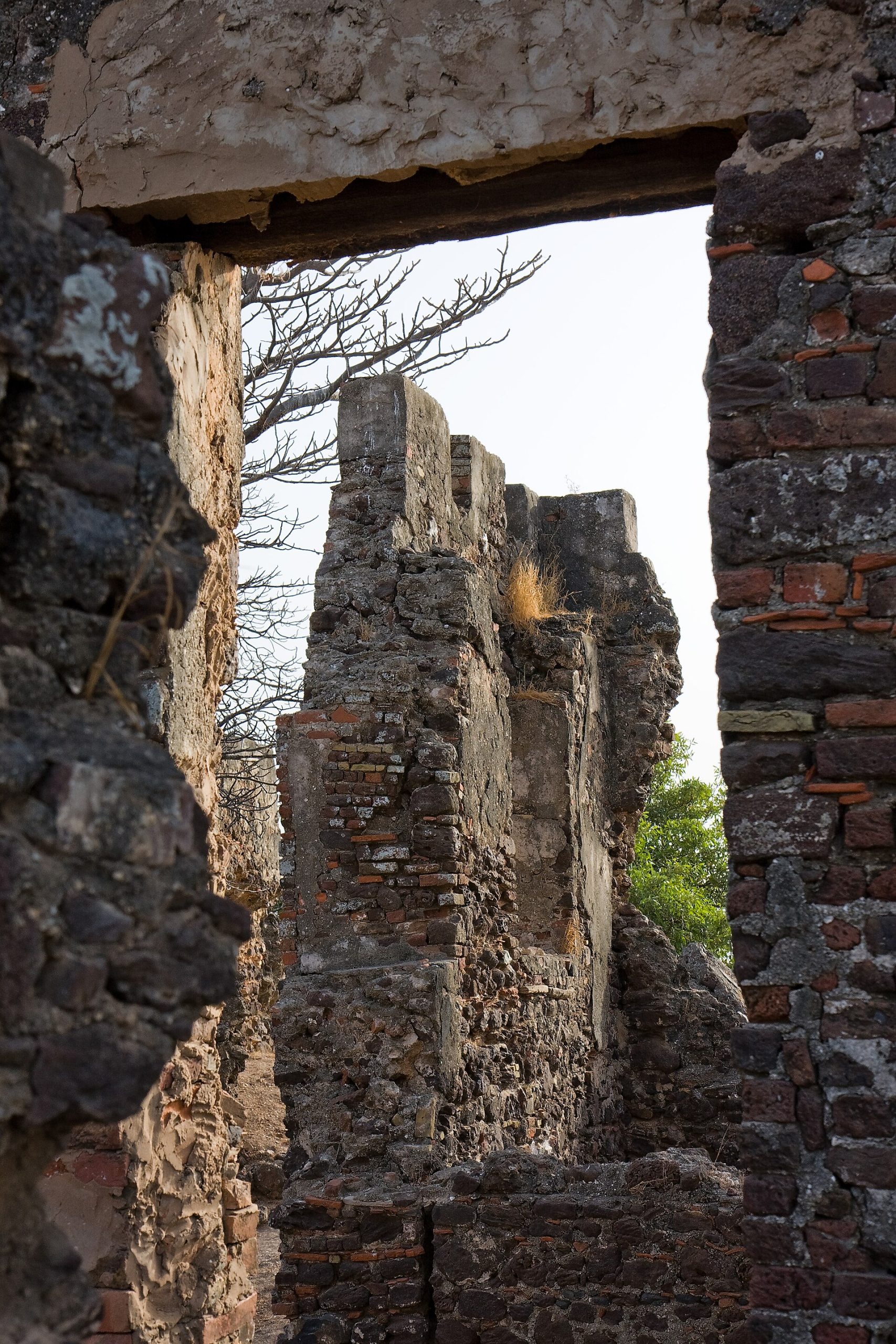
Once on the island, give yourself time to walk slowly among the ruins, to sit beneath the baobabs, and to absorb the atmosphere of the place. A knowledgeable guide is invaluable here, not only to explain the fragmentary remains but to help convey the human weight of the history. Pair the island with the museum and village at Juffureh to round out your understanding.
View 13.3175, -16.3614 on Google Maps
Come to this place, above all, with respect. This is not a site for casual tourism but a memorial to profound suffering and endurance, and it rewards a thoughtful, unhurried visit. For many, especially those with roots in the African diaspora, it is a deeply moving pilgrimage. For all visitors, it offers a chance to stand at one of the sources of the modern world’s history and to remember what happened here.
Practical arrangements are best made through reputable local operators who can handle the boat crossing and provide knowledgeable guides, and it is worth checking conditions in advance, as access can depend on the tides and the state of the river. But the logistics, though real, are secondary to the spirit in which you come; this is a place that asks something of the visitor, and gives a great deal in return.
Timing your visit thoughtfully can deepen the experience, and many find that approaching the island in a reflective frame of mind, perhaps having first visited the museum at Juffureh, allows its significance to register more fully. However you arrange the practicalities, the essential thing is to arrive ready to listen, to look, and to remember, for that is what this particular place most asks of those who come to it.
Castles Nearby
You May Like
Mafra, the Palace a King Built From a Vow