Timarhane Island
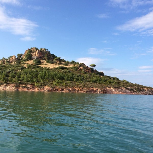
The island, which is located right across the Çamlık bay, was used as a psychotherapy center during the annexes. Those who drink too much drink or those with mental disorders would bring them to the island and leave them to the island, the natural beauties and those who came to their heads with the strong wind from the rocks would mingle with the people again, and those who did not mind would watch a little more scenery and listen to the sound of the wind.
There is a small monastery on the island, which has panoramic views of Cunda Island, Tavuk Island and Çamlık Bay.
In ancient times, Greeks called the island “Aya Paraskevi” and Turks called it “Taşlı Monastery”.
Devil’s Table

Located on an old lava deposit on steep cliffs, Şeytan Sofrası is reminiscent of a round table. It is rumored that the hollow in the iron cage on one of the rocks on the hill, resembling a large footprint, is the “DEVIL’S FOOTPRINT”. Considering the size of the devil’s foot and the price of shoes, it is understood that the devil’s shoes are quite expensive.
The fact that this place is located on a land dominated by the sea, bays and pine groves, has a panorama that includes the island group including Ayvalık, Alibey (Cunda) Island and the Sarımsaklı region, especially the unique beauty that occurs during the sunset attracts the attention of local and foreign tourists.
On the way from Sarımsaklı to Ayvalık, the hill is reached by an asphalt road that passes through the pine forest on the left of the road, and transportation is provided by taxi from the center of Sarımsaklı in summer.
Saatli Mosque is located in the center of Ayvalık, in Fevzipaşa District. It was built during the period when Ayvalık was economically strong. The church was built in 1870 and turned into a mosque in 1928. Today it is known as Saatli Mosque.
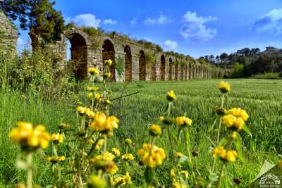
It was built on the area where sloping and flat floors meet. Although the total area of the church is 1250m², the church was built on 375m². The height of the church is 24 meters. The height of the bell tower is 24 meters and the height of the minaret is 44 meters.
It is the second tallest church in Ayvalık. The outside length of the church is 23.50 m and its width is 13.30 m. (east), 14.40 m (west)
Çınarlı Mosque is located in the center of Ayvalık in the Alibey Street of Hamdibey District. The church was built during the autonomy period, when the people of Ayvalık were economically and politically strong. (It was completed in the 1790s.) The building was converted into a mosque in 1923.
The plan of the church, which forms a rectangular image, is the Greek Cross. Since the church was built on a partially sloping flat area, organic and grid textures were used together. The total area of the church is 2800 m² and the church building floor area is 600 m².
The height of the church is 30 meters and the height of the minaret is 38 meters. The church, which has a rectangular plan, three naves and three apses, is 32.40 m. Width, 15.90 m. (east) is 20.25 m (west)
Its naos is divided into three naves by five columns. The capitals of the columns connected to each other by arches are in Corinthian order. The middle nave is covered with cross vaults in the barrel side naves.
When the church was converted into a mosque in 1923, the muezzin hall and mihrab were added. There is an arched door and a window on the south wall of the beman. There are niches on the west and east sides of the northern wall of the beman. These niches are also found on the wall of the naos and where the apse joins.
The iconostasis was built by raising three steps from the ground. The section of the iconostasis in the middle nave is divided into seven by six columns. There are panels with icons in between the columns. The icons are not available in their places today. Panels are covered with plaster.
Located in Hayrettin Paşa Neighborhood, the church was built in 1850. It is one of the first churches in Ayvalık. Turned into a mosque in the