The island that gives its name to the region is located in front of Kaleköy and transportation is done by boats. The island, whose closest point to the shore is 500 meters, is 74 km long, thin and narrow. The maximum depth between the island and the shore is 104 m. Wild olives grow mostly on the island, which is covered with maquis and sometimes red pine trees. There is also a fresh water source on the island. Daily tours to the region are made by boats from Demre and Kaş.
It is known that the name of the city is “Khawakuwa” in the Luwian/Etruscan original and means “Land of cattle/bulls”. The word “Khawa” has been translated into English as “cow” and into German as “Kuh” through phonetic variations, and is used with the same meaning in these languages. From here we understand the existence of the “Bull/wall/cult” in Kekowa and that it is the shelter and sacred breeding place of sacred animals such as cattle, bulls and cows.
As a matter of fact, the Turkmens, who came to the region in the 2nd century and settled on the opposite shore of the island, have preserved this custom by leaving their animals on the island every year. In addition, the name Kekova can be read meaningfully with the old script Gök=Köktürk. Accordingly, it is seen that Kekova means “İngögova / mavigökova”. The ruins of the settlement with the same name are on the northern side of the island facing the mainland.
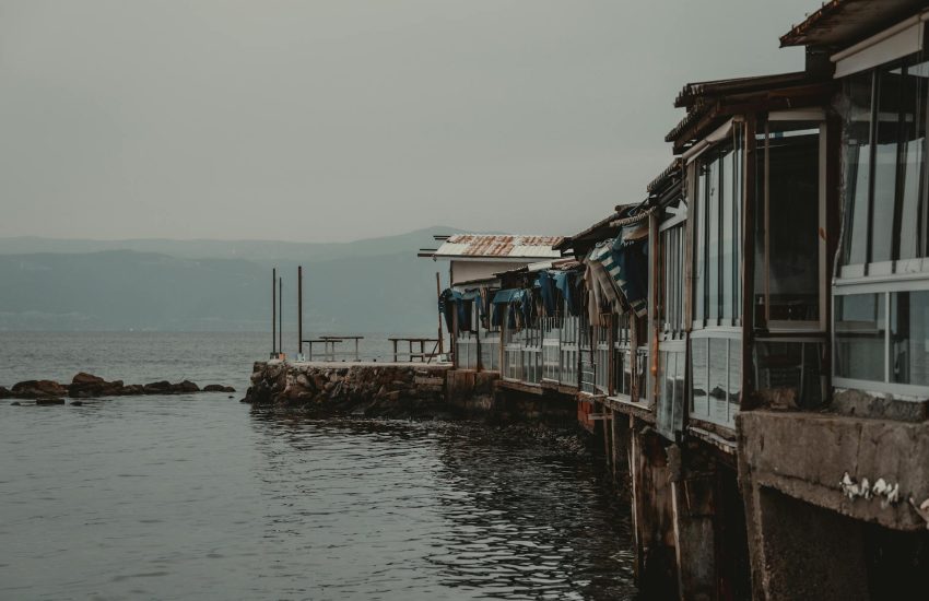
It is understood from the structures buried in the sea seen on the northern coast of the island that the island was buried a few meters into the sea due to the earthquake in ancient times. After the earthquake, those who survived settled in the sister cities of Simena and Teimiussa on the opposite coast. When we approach the mainland side of Kekova Island by boat, we can see the harbor walls, shops, pedestrian paths and stone stairs of the Sunken City in the water.
It is also seen that some of the houses are submerged in the sea and some are above the sea. As a result of the Orthodox missionaries in Tersane Bay spreading their religion in Lycia, A.D. There is a surviving apse of a Byzantine church with a square plan and decorated with frescoes, thought to have been built in the 5th century. SIMENA / ÜÇAĞIZ KALEKÖY The ancient city of Simena is on the peninsula opposite Kekova Island.
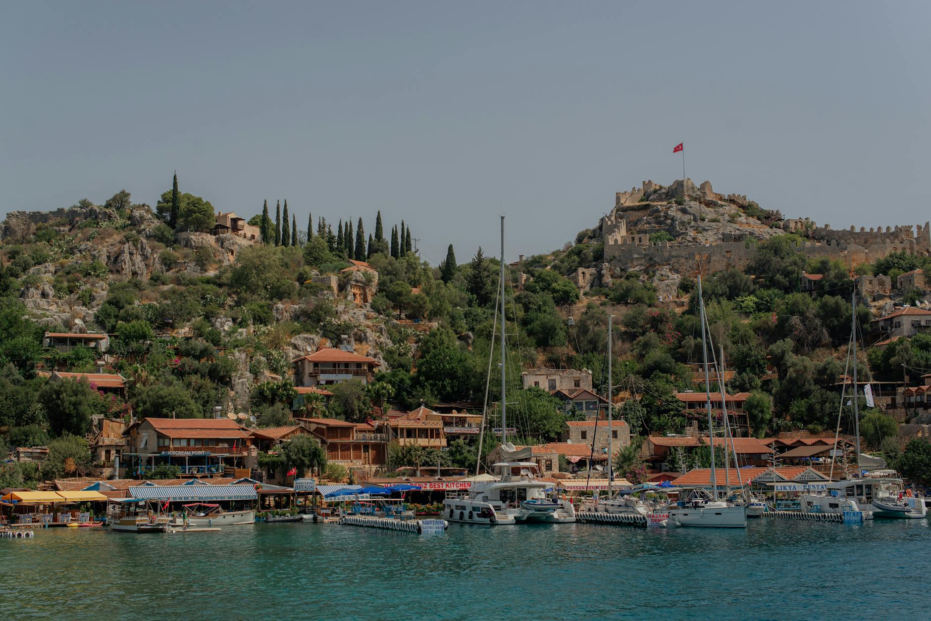
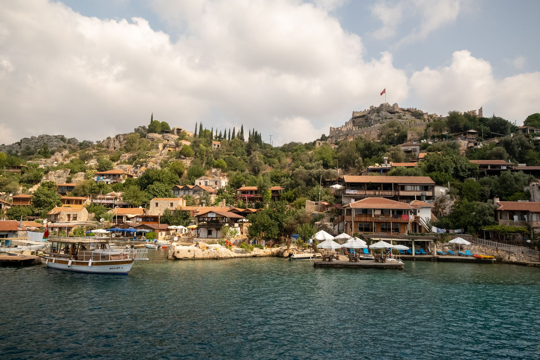
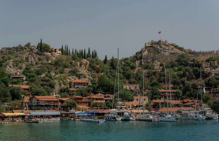
Among the historical ruins is the small fishing village Kale. You can reach Üçağız village by land after 20 km by going south from the Demre-Kaş highway. You can come here by boat tours from Demre/Çayağzı and Kaş. All kinds of services are provided to boat and yacht tourists at the fish restaurants on the seaside. Kallipos is a hero who was among the founders of the city of Simena.
It appears that the name Simena is a phonetic corruption of the Luwian/Etruscan word “Soamawana” meaning “Great Motherland”. The name of the city is mentioned as Somena in a work of the Byzantine historian Stephanos. The history of the city dates back to 3000 BC. B.C. It is understood that the Kallipolians/Gelipolians, allies of Hector of Troy during the Trojan War in the 12th century, settled in Soamawana.
The city later joined the Lycian Union and produced its first coin in BC. It was printed in the 4th century. When the city of Kekova was buried in the sea by an earthquake, the population of Simena increased with the participation of the survivors of this disaster and the city expanded beyond the castle. Simena, which was invaded by pirates for a while, preserved its Luwian/Etruscan culture and language as an independent city during the Roman period. It lost its importance due to the earthquake and drought in the 9th century.
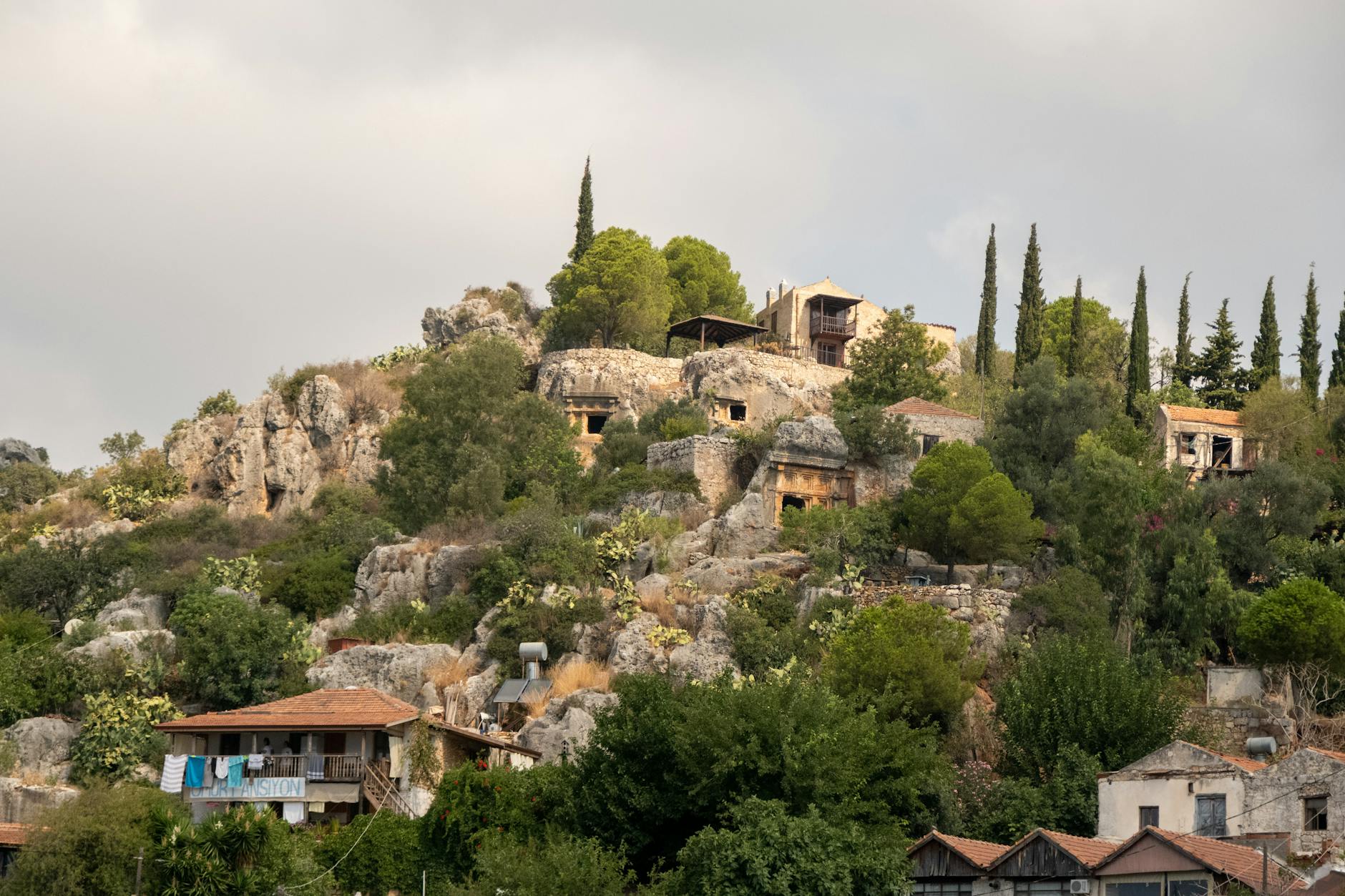
The first place that draws our attention in the region is the Acropolis Castle, which is surrounded by octagonal and polygonal wall systems. The pointed arches of the bastions are an architectural cultural feature of the Etruscan/Thracian tribe. The walls were restored during the Byzantine period and the Middle Ages. The main entrance gate of the castle is rectangular and made of smooth block stones. There are water cisterns inside the castle. There is also a small theater with a capacity of 400 people with 8 rows of caves.
The structure behind the orchestra, which has a dirt floor, suggests that the players undressed and dressed in a wooden cubicle. The fact that the smallest theater of the Lycian region was built here can be attributed to the fact that the male population engaged in fishing and maritime was constantly separated from their cities.
On the outer part of the walls facing the sea, there is the stoa of Poseidon’s temple. When you go down to the shore, you can see the ruins of the bath, which had a rectangular plan and was built with a polygonal wall system. An inscription stating that the bath was gifted to Emperor Titus attracts attention. House ruins can be seen at various points in the region.
More than 20 house-type rock tombs were carved into the rocks in the form of windows and doors, and information about the deceased was written on them in Lycian language. The sarcophagi are stone carved and their covers have pointed arches. Several towers and various Lycian tombs can be seen among the ruins of the ancient city of TEIMIUSSA, located in Üçağız Village, just west of Simena.
In the inscription on the front of a Lycian tomb, it is written that the person buried here belongs to a person named Kluwanimi, proving that it was originally a Luwian/Etruscan settlement and that its people were of Luwian origin.
APERLAI/SICAK PIER The ruins of the ancient city Aperlai can be seen on the south-facing side of the narrow and long gulf named Hot, which is located in the east of Kaş Bay and is the second largest natural harbor in central Lycia. The natural harbor is like a Dead Sea and is surrounded by high hills on three sides. It is known that the original name of the city is “Aprillai”, which means “River Gorge” in the Luwian/Etruscan language.
In the Luwian/Etruscan language, the word “Apr/Abra” means “River” and the word “ela/ila” means “Bosphorus”. As a matter of fact, even today the region is called “Akar Strait” because it is located at the inner end of a gulf in the form of a very thin and long water passage. It is known that the city existed in the same period as other Luwian settlements in the region, such as Kekova and Simena. B.C.
The city, which was founded on a previously existing small Luwian port unit by the “Aprilla” people, who were among the Nordic tribes that migrated to Anatolia in the 3000s, grew over time and was built in B.C. In the 6th century, it was included in the Lycian Union like neighboring cities. Aperlai, which had the right to represent sister cities of Aprilla in the Lycian Union, minted its first coin in the 5th century. B.C.
The city, which was captured by pirates in the 1st century, had one vote with Simena – Apollonia and Isinda in the Roman Lycia provincial council, and they were collectively referred to as “Aprillas”.
During the Gordian period, various structures of the Lycian City were restored and new structures were built outside the city towards the coast and reached its largest state. During the Byzantine period, the city walls were repaired and the Orthodox Basilica was built and displayed within the episcopal administration center. The ruins of the city are within the walls built in rectogonal and polygonal techniques, 100 m above the sea. There are protection castles on both sides of the square-shaped walls.
A stone architrave block, 15 m wide and 3 m long, was placed under a semicircular pediment above the main entrance gate. The Byzantine Church ruins in the north-west corner of the acropolis-shaped castle attract attention. There are three square-planned defense towers on the northern walls. There are ruins of a small Byzantine chapel inside the castle.
Over time, the castle walls were extended perpendicular to the shore in the north-south direction, and at the farthest point, gaps were built within the harbor walls, right on the seashore, every 15 meters for pulling boats. 50 m. The buildings behind the harbor walls were used as warehouses and magazine shops. The necropolis of the city is to the east of the castle walls and contains Lycian sarcophagi with flower and plant reliefs.
In some of these, information regarding the identity of the deceased is engraved.
APOLLONIA / KILINÇLIThere are ruins of the ancient city of Apollonia in the Kılınçlı village settlement in the inner land, 20 km north of the coastal city of Aperlai in the Central Lycia region. It is known that the name Apollo is “Apullwan” of Luwian/Etruscan origin and is used like a Greek word as a result of phonetic distortion. As a matter of fact, it is known that in the Luwian/Etruscan language, Apa means water and ula/ulla means grove/shrub.
Accordingly, the name of the city means “Apullwana/abode of the gods worshiped in the water grove”. It is understood from an inscription here that the city was founded by people of the same ethnic origin who separated from Aperlai as a result of a dispute during the Lycian period. In this inscription, the people of the city refer to themselves as “Apollonian Aprillas”. Apollonia, which was included in the Lycian Union, minted its first coin during the Roman period. The development of the city took place during the Byzantine period.
During this period, the city walls were restored. The city’s theater was used as an open-air basilica. The city was plundered by Arab raids after the 7th century and was later attacked by Genoese and Rhodes pirates, thus losing its character over time. The ruins of the ancient city are 90 meters north of Kılınçlı Village. It is located on an acropolis hill and slopes at a high altitude.
The first thing that attracts attention in the region is the acropolis city walls, the foundations of which were built with cyclopean type shapeless stones in the Lycian period, and were later restored with rubble stones in the Roman and Byzantine periods. The walls to the west of the walls surrounding the entire acropolis hill are still standing.
It is thought that the main gate is in the south direction and is protected by towers built on both sides. A few rows of caveas of the theater built on the rocky slope can be seen, but they are completely destroyed. Additionally, many water cisterns with bell tower-shaped mouths attract attention in the region. There are Lycian type sarcophagi in the necropolis on the northern slope of the acropolis hill.
The most interesting tomb is the square-shaped Mausoleum, rising on a stone plinth, with a quadrangular stone podium at the bottom and a stone-carved sarcophagus in the shape of a house roof decorated with geometric and various plant motifs.
You May Like
Kekova Pictures