
Ayvalık was founded on the area formed as a result of the collapse of the part called Aegeid in the Pliocene – the end of the third period and the beginning of the fourth period in the Quaternary. During these periods, the group of islands (22 islands) in front of Ayvalık were called “Hekatonnesoi”. This name comes from Apollo, the chief god of the city of Nesos. According to the research, there were Greek colonies in the group of islands in front of Ayvalık, and Ayvalık was later moved to where it is today.
In his book, Strabo showed the surrounding area as a settlement of Lelegs, Pelasgians and Carians. When the Carians had to migrate from their regions, they had to migrate to Anatolia and settled in Ayvalık and the surrounding islands.
Strabo strengthens his claim with the fact that the mentioned tribes made their living by seafaring and piracy, the abundance of trees suitable for shipbuilding in the region, and the abundance of minerals such as copper and lead in the region.
Aeolian ruins were also found. According to this view, B.C. In 1500, people from Greece founded a city on the Anatolian coast and islands. This tribe was called Aiol. They founded 12 cities, including Lesbos, from Çanakkale to Gediz.
One of these 12 cities was founded on the coast to the east of Cunda island. And this city managed to survive until Alexander the Great conquered Anatolia. Doğan Aka wrote in his book “Ayvalık Economic Geography” that the city was founded for military purposes between 1430 and 1440.
Although there is information about the Yunt (Today’s Cunda) islands in Piri Reis’ Kitab-ı Bahriye, no information about Ayvalık has been found. Although there is extensive information about this region in Seyyid Noah’s Atlas and the Near East map prepared by Ahmet III in 1726, no information about Ayvalık has been found.
In the map showing the entire Aegean Coast in Evliya Çelebi’s Travelogue, there is no information about Ayvalık or its settlement mentioned.
There is no definitive record of the origin of its name.
However, there are different opinions on this subject. In his book titled “Ayvalık History” by the Greek writer Yorgi Sakkari, who is known for his research on the history of Ayvalık, he writes that the people who came here came from the town of Lesbos Island called “Balçık” in Turkish and “Kidonie” in Greek, and that the name of this place was inspired by this and named “Kidonie”. The mussel species “Ayfada” (Quince) is shown. In the book “Ayvalık” by the French historian Raffanel, it is written that the name comes from the Quince trees that were abundant in the region at the time.
This claim has never been verified and it has always remained as quince trees that once existed.
The first information about Ayvalık houses dates back to the 19th century. There are no information or documents regarding the residences before this period. Considering that the population density in Ayvalık at that time was Greeks, it becomes clear that the first owners and users of the houses that existed at the specified date and today were Greeks. When the historical process of Ayvalık is examined carefully, it is seen that there are not many Turkish settlements in the city.
Even if there was, it seems that this was terminated with the autonomy certificate given to Ayvalık. The city completed its structural formation during the period when the Greeks lived. The Greeks built the houses considering their own needs and used them until the population exchange.
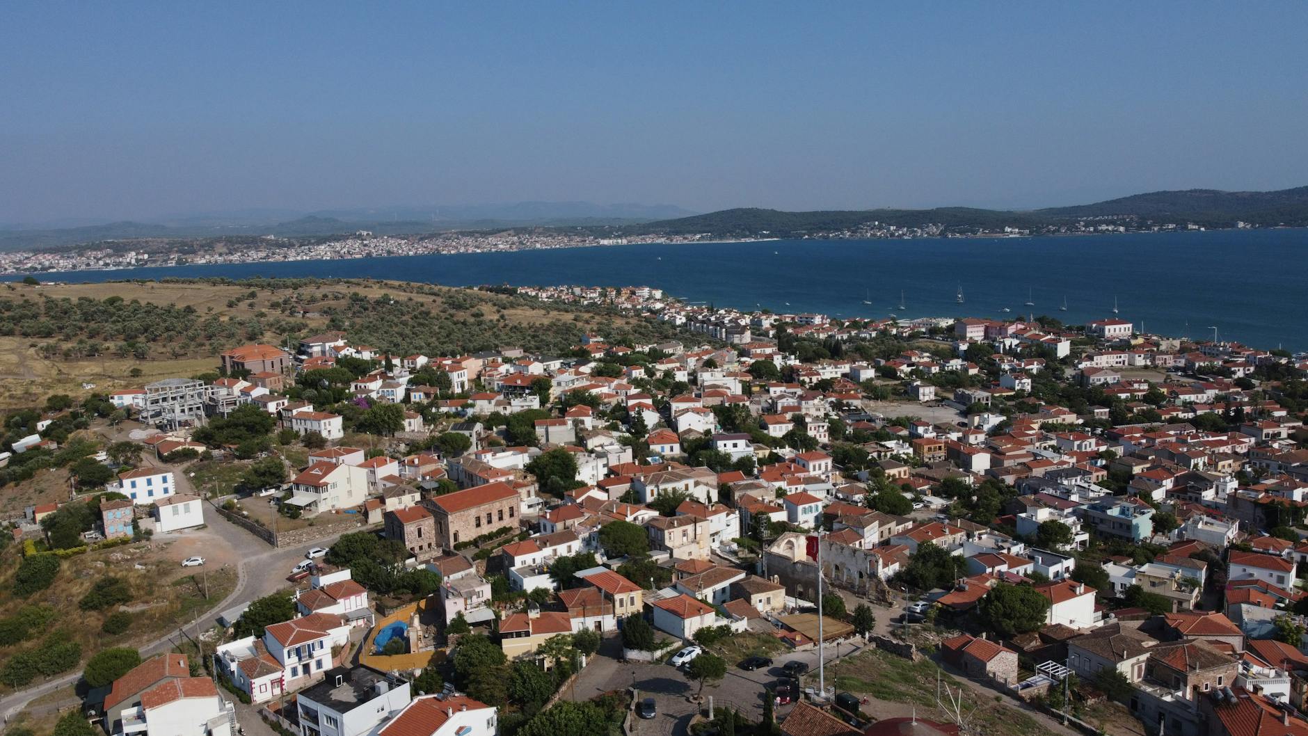
After the exchange, changes took place as the houses began to be used by the Turks, but this process of change ended with the protection law. In the city built at the foot of the hill, the roads are uphill and narrow, and there are many dead-end streets. The side streets descending vertically towards the sea end with the main streets running parallel to the sea. There are commercial establishments running parallel to the seashore under the road.
What attracts the most attention in the settlements is that they are small and built adjacently.
Tımarhane Island, located just across Çamlık Bay, was used as a psychotherapy center in ancient times.
They brought those who had drunk too much or had mental disorders and left them on the island. Those who came to their senses due to the natural beauties and the strong wind blowing from the rocks, mingled with the people again, and those who did not come to their senses watched the view a little more and listened to the sound of the wind. There is a small monastery on the island, which has a panoramic view of Cunda Island, Tavuk Island and Çamlık Bay. In ancient times, the Greeks called the island “Hagia Paraskevi” and the Turks called it “Stone Monastery”. they used to say
Devil’s Table Located on an old lava deposit on steep rocks, the Devil’s Table resembles a round table.
It is rumored that the hole in the iron cage on one of the rocks on the hill, resembling a large footprint, is the “DEVIL’S FOOTPRINT”. Considering the size of the devil’s foot and the shoe prices, it is understood that the devil’s shoe is quite expensive. It is located on a land overlooking the sea, bays and pine groves, and has a panorama of the island group including Ayvalık, Alibey (Cunda) Island and the Sarımsaklı region, especially during sunset. Its unique beauty attracts great attention from local and foreign tourists. The hill, which can be reached by an asphalt road passing through the pine forest on the left side of the road while driving from Sarımsaklı towards Ayvalık, can be reached by taxi minibuses from Sarımsaklı center in the summer months.
Saatli Mosque is located in the Fevzipaşa District in the center of Ayvalık. It was built during the periods when Ayvalık was economically strongest. The church was built in 1870 and was converted into a mosque in 1928. Today, it is known as Saatli Mosque. It was built on the area where sloping and flat ground meet. Although the total area of the church is 1250m², the church was built on 375m². The height of the church is 24 m.
The height of the bell tower is 24 meters and the height of the minaret is 44 meters. It is the second tallest church in Ayvalık. The external length of the church is 23.50 m and the width is 13.30 m. (east), 14.40 m (west)
Çınarlı Mosque is located on Alibey Street in Hamdibey District, in the center of Ayvalık. The church was built during the period of autonomy, when the people of Ayvalık were most economically and politically powerful. (It was completed in the 1790s.) The building was converted into a mosque in 1923. The plan of the church, which forms a rectangular appearance, is a Greek Cross. Since the church was built on a partially sloping flat area, organic and grid textures were used together.
The total area of the church is 2800 m², and the floor area of the church building is 600 m². The height of the church is 30 m and the height of the minaret is 38 meters. The external length of the church, which has a rectangular plan with three naves and three apses, is 32.40 m. Width, 15.90 m. (east) 20.25 m (west) Its naos is divided into three naves with five columns each. The capitals of the columns connected to each other with arches are in the Corinthian order.
The middle nave and the side naves were covered with cross vaults. When the church was converted into a mosque in 1923, the muezzin’s gallery and mihrab were added. There is an arched door and a window on the south wall of the bema. Niches were placed on the west and east sides of the north wall of the bema. These niches are also found on the wall of the naos and in the sections where the apses meet. The iconostasis was built by elevating it from the ground with three steps.
The central nave section of the iconostasis is divided into seven by six columns. There are panels with icons between the columns. The icons do not exist in their places today. The panels are covered with plaster.
The church located in Hayrettin Paşa District was built in 1850. It is one of the first churches in Ayvalık. It was converted into a mosque during the Republic Period and named Hayrettin Pasha Mosque. The name Panayia is a name given by the Orthodox to Mary. It was the church of schools that provided religious education at the time. The total area of the church, which was built on a flat ground, is 4000 square meters, and the area of the church building is 700 square meters.
It is the church with the largest floor area in the city. The height of the church is 18 meters and the height of its minaret is 32 meters. At the time, there were church parsonages and two educational buildings in the garden. Today, the church is used as a mosque and the educational buildings are used as primary schools. The church has three naves and three apses. The basilica-shaped church, built without a dome, is a long building with a rectangular plan.
The west and east facades of the church are wider than the other facades. The length of the church is 25.25 meters and the width is 15.80 meters. The naos of the church has three naves and the middle nave is wider. The naves end with three apses.
Taksiyarhis Church is located in the İsmet Paşa District in the center of Ayvalık. It is understood from an inscription on the church wall that it was built in 1844. It was built on an area slightly higher than the road by flattening a sloping hill and filling it. Although the total area of the church is 1200 m², the church was built on an area of 500 m². The height of the church is 16m. The height of the bell tower is 30 meters.
The length of the church from the outside is 22.00 m and the width is 12.75 m. The church courtyard is entered through a seven-step arched entrance door supported by two columns. There was a bell tower above the gate. But the bell tower does not exist today. Apart from the main door (to the west), there are two more doors that provide access to the courtyard. The second door provides access to the courtyard via internal steps, while the third door is completely covered with a wall.
Garlic stone was used on door pillars and stair steps. The garden entrance doors are made of iron and are original doors. The entrance doors to the church were changed later.
Hagia Triada Church is located in Kazım Karabekir District in the center of Ayvalık. The church was built on a large area on flat ground, with a longitudinal rectangular plan and a flat roof type. The land area of the church is 2000 m² and the ground floor area is 400 m². It is the fourth tallest church among the churches in the city. The external length of the church is 23.00 m and its width is 18.20 m. The place of worship is 19.40m from the inside. Its width is 12.75m. The height of the church is 17 m.
The church is a long building with a rectangular plan. The west and east facades of the church are wider than the other facades. The naos has a rectangular plan and has two central naves on both sides. The naves are aligned in the east-west direction. The supporting columns are made of plaster coating technique on wood, and the column capitals are made of plasterboard technique. The capitals of the columns are in Corinthian type.
There are plaster panels on the top of the columns. It is thought that these panels contain icons of saints, just like in Taksiyarhis church. The panels are now covered with plaster. The main entrance is provided through a double door in the west of the Naos. To the east of the naos is the bema section, which can be reached by three steps. The only apse of the church is in the eastern part, and the narthex is located in the west.
During the periods when the church was used as a warehouse by the monopoly, the nave of the church was converted into two floors with wooden flooring.
Faneromeni (Ayazma) Church, which is lost among the buildings in Kemal Paşa District, is called Ayazma or Faneromeni because the water inside the church is considered sacred. Its name means “holy water”. 1890 is written on the pediment at the entrance of the church. It is the late period structure of Ayvalık. The church was built on this date. Located on a flat ground, the church has a grid planned texture.
The total land area of the church is 200 m² and the construction area is 150 m². The external height of the church is 17.40 m. Its width is 8.60 m. The height of the church is 12 m. Unlike other churches, it was built in the northeast-southwest direction without taking religious concerns into consideration.
In addition, the church does not have an apse. The church, which has four windows each on the southeast and northwest facades, was closed later on the door on the northwest facade, and the door on the southeast facade was closed and turned into a window. Two doors were later added to the northeast wall. There is no iconostasis in the naos. A mezzanine floor was added to the church, which was used for various purposes over time.
Supporting columns were not used in the naos, and it was covered with a single open roof and a gable roof. On the roof, which is divided into square sections, a plaster flower relief is placed in the middle of each section. The narthex, which is accessed by steps, is covered flat and plaster flower reliefs are also found in this section. There are also four carrier columns in this section.
Portaitissa Church is located in Sakarya District in the center of Ayvalık. The church, located on a slightly sloping ground, has a grid planned texture. Although the total area of the church is 1163 m², the church was built on 135 m². It is the smallest church in the city. The height of the church is 8 m. The external height of the church is 13.05 m. Its width is 7.35 m.
Portaitissa Church is the smallest church in the city in terms of floor area and height. It is a long building with a rectangular plan in the northwest-southeast direction. The church has a single nave and a single apse. Unlike the others, the main entrance of the church is not located opposite the apse. The apse on the southeast wall of the naos has a semi-circular projection inside and outside.
There is a window in the middle of the apse and a niche on both sides. The iconostasis wall is divided into seven parts with eight plasters in front of the southeast wall. The apse is accessed through a wide door in the middle and a narrow door on each side. There were icons in the sections between the doors. None of the icons in the church exist today. The upper cover of the naos is covered with a barrel vault on the inside and a barrel roof on the outside.
The narthex is covered with a wooden roof on the inside and a hipped roof on the outside. Tiles were used on the roof. Six windows and a door open into the naos, narrowing from outside to inside. All windows except the window opening to the bema are rectangular in style. The window opening to the bema is in a round and arched style.
You May Like
Amasya Hotel Pension Accommodations