Korydalla, today called Hacıveliler, is one kilometer west of Kumluca district center and twenty-nine kilometers northeast of Myra. The place name Korydalla, whose name was confirmed by a statue base honoring Emperor Marcus Aurelius in Hacıveliler, is derived from the Greek word “Korydos” (lark). It was stated that it was a Rhodian city by Hekataios of Miletus in 500 BC. Pliny shows Korydalla between the cities of Rhodiapolis and Gagai, and Ptolemyissos opposite Mount Masekitos. It is mentioned as “Coridallo” in Tabula Peutingeriane. It is counted among the Lycian cities of the Late Antique Period by Hierocles. Korydalla constituted an important traffic point where the routes of Patara Stadiasmos intersected. The history of Korydalla, which has an inscription in Lycian language, should be examined largely through Rhodiapolis. It is known that the city joined the Lycian League and was represented together with Rhodiapolis.
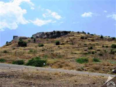
Korydallas, the spy who guided the Persian armies in the 5th century BC, is a member of this city. Korydalla was among the thirty Lycian cities helped by Opramoas of Rhodiapolis after the earthquake in 141 AD. A Leto Temple is epigraphically documented in this city. III. It minted coins during the Gordian and Tranquillina periods. The city, which continued its existence during the Roman period, only developed during the Byzantine and Late Byzantine periods. The city, whose location was identified by an inscription found by Spratt and Forbes, was founded on two hills and their foothills.
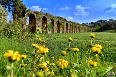
The main works that stand out in the ancient city today are the bathhouse, the waterway, the cisterns on the Büyük and Küçük Asar hills, rock tombs and a large building with mosaics showing elaborate masonry. The waterway is on the side of the dirt road leading to Şeyhköy of Kumluca district and continues for approximately five hundred meters along the road. Six rock tombs are found on the western slope of Küçük Asar Hill, located in the southwest of Büyük Asar Hill. In one of the graves, there is an L-shaped kline with a height of 0.80 meters from the ground. Another of the graves has a double-storey kline. The other two graves are vaulted.

Although there is a theater stated by ancient sources on the southeastern slope of Küçük Asar Hill, no trace remains on the ground today. There is a rock tomb at the foot of the hill near the town side, and right above it is a very dilapidated sarcophagus with the boat part carved into the rock. When climbing the Büyük Asar Hill from the east, you can find remains of walls, presumably city walls, among the rocks. Only a small part of the rock-carved stairs reaching the hill has been preserved until today. There are cisterns on the hill. Some of the cisterns were carved into the rocks and adapted to the shape of the rocks and are plastered. Some of them show a rectangular plan. On the eastern slope of the hill, a large rock block was smoothed and a typical Lycian tomb was built. The tomb in question reflects an example of wooden architecture. The interior of the rock tomb has three klines. The bath is located on the plain between Büyük Asar Hill and Küçük Asar Hill. The hypocaust system made of bricks can be observed on the lower floor of the bath, which is in a very dilapidated state and a definitive plan cannot be obtained. Korydalla is also known for its gold and silver church items, some of which were smuggled abroad, which have a special place in Byzantine mining art and are referred to as the “Kumluca Hoard” in the archaeological literature.
Korydalla is among the “Ancient Cities of the Lycian Civilization” (2009) recommended to the UNESCO World Heritage List.

Source: “Korydalla”, Antalya from Past to Today [II. Volume], Antalya Provincial Directorate of Culture and Tourism (2012)
Places to Visit in Antalya
Source: Antalya Provincial Culture and Tourism Directorate