8 km to Kaya Village by following the mountain road that continues from the south of Fethiye. It is possible to access it later. As an alternative, you can reach Kaya Village by following the highway from Fethiye to Ölüdeniz to the west from the Hisarönü junction. The first of these roads provides access from the north, the other from the east, to the small plain surrounded by elevations, which the locals call Rock Pit.
The entrance towards Hisarönü welcomes visitors with buildings abandoned after the population exchange. At the entrance in the north, the visitor is treated to the panorama of Kaya Village and the magnificent stance of Baba Mountain rising alone in the east. Our suggestion; No matter which way you come to the Rock Pit, returning by the other route will be beneficial in terms of getting to know the environmental texture and pleasing in terms of the landscape it offers to the visitor.
An attentive visitor may notice sections of old roads on both routes.
Geographer and ancient writer Strabon; After describing the Telmessos City and Port in the Lycian Region, “… one reaches a steep mountain. Here one comes to Karmylessos, which is settled in a narrow and deep stream.” With its detection, it indicates the existence of the ancient city of Karmylessos, whose exact location has not been determined until today, near Telmessos.
In some superficial findings and signs; The location of Karmylessos Ancient City is identified with Kaya Village today. Although there are some ruins from the ancient period in Kayaköy and its surroundings, they are far from revealing the existence of a comprehensive city.
At Gökçeburun Location, at the entrance to the Rock Pit from the north; BC. Three sarcophagus tombs dating back to the 4th century and the same number of rock tombs with Lycian inscriptions on them can be shown as the oldest and most comprehensive ruins that have survived from ancient times in the region. Apart from this, the rock-carved tomb north of the Girls’ School in Kayaköy is a local work from the same period.
The region was discovered in the 19th century. Fellows who also visited; He adapts Karmylessos to Gemiler Island, located south of Kayaköy. Fellows’ detection and the areas where the above-mentioned remains were found; It is far from harmony with the City of Karmylessos whose silhouette was drawn by Strabo.
Apart from these, the ruins of a small castle from the Hellenistic Period, hidden under the late period walls on Asarcık Hill in the south of Belen District, and the local settlements from the Classical Period to the Byzantine Period, located on the dominant ridges to the south of Turunç Spring, are areas that can be reached by curious and interested visitors with plenty of time, only with the help of a local guide.
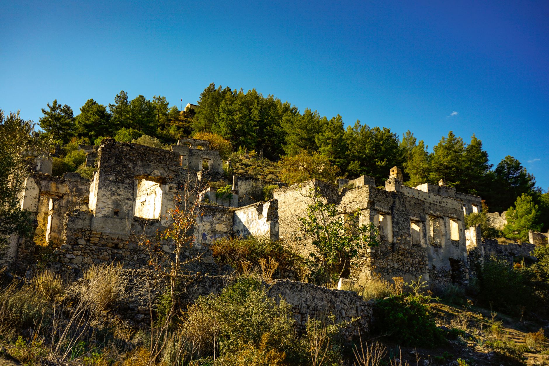
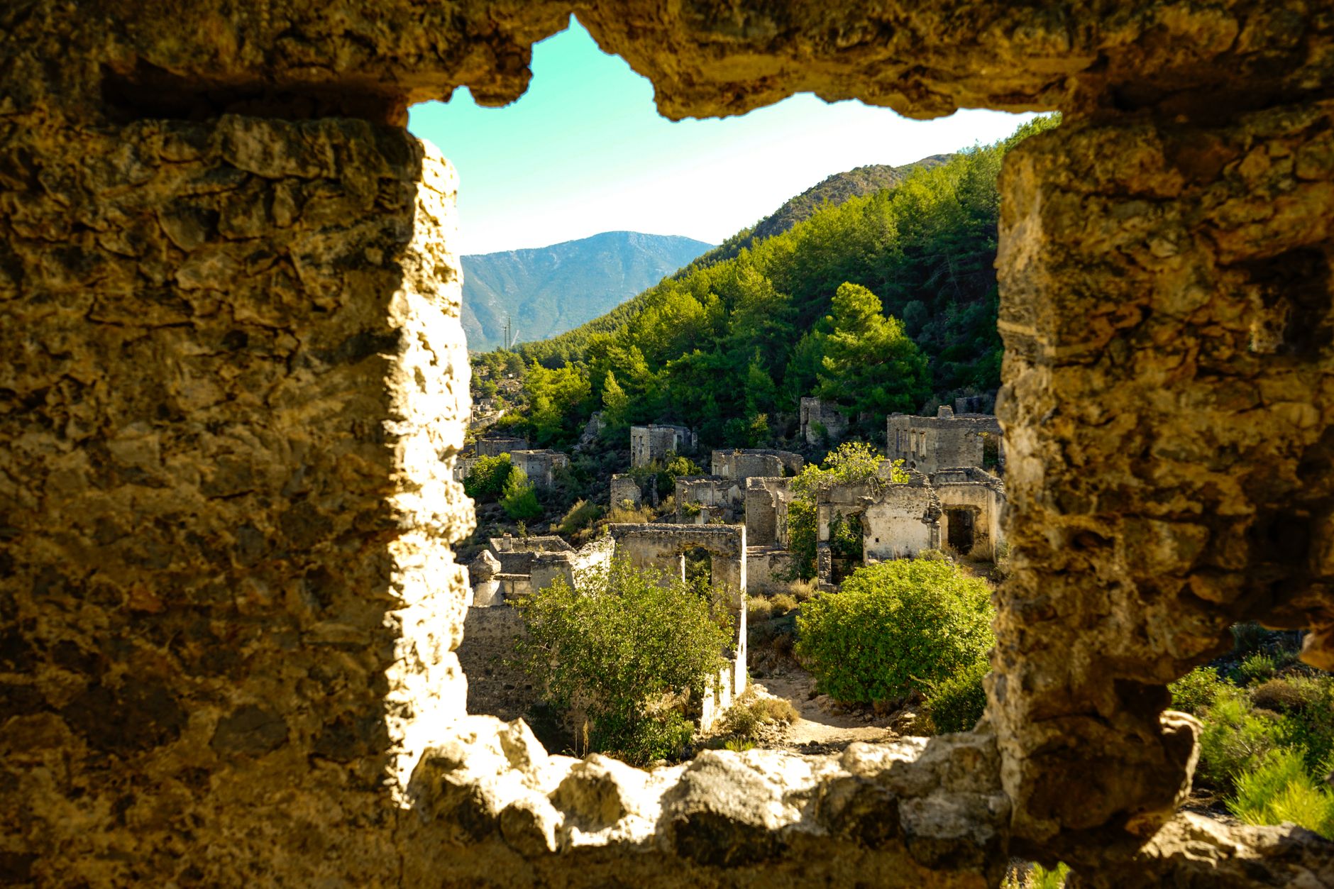
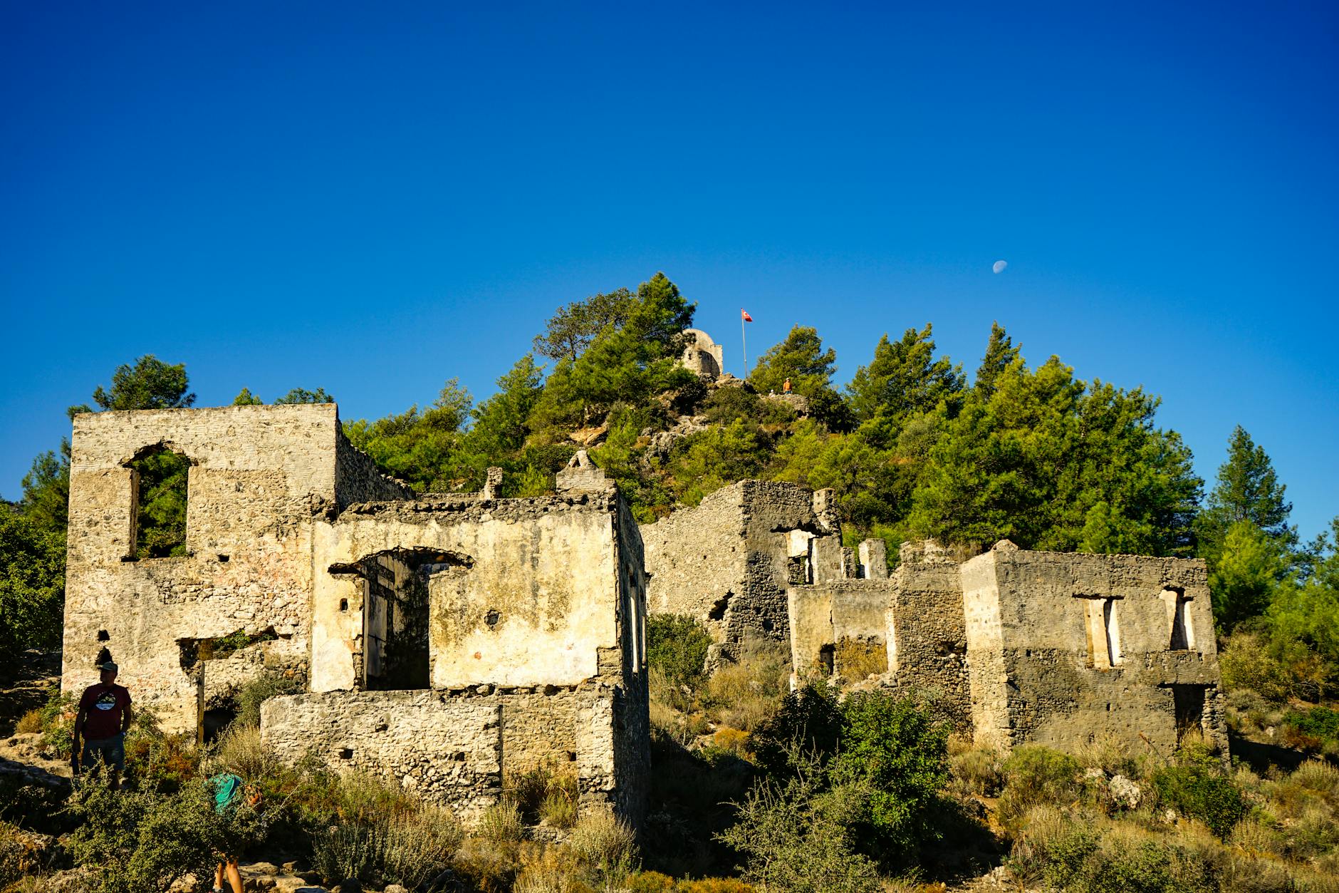
Today’s popularity of Kaya Village stems from the existence of an abandoned Greek city abandoned as a result of the population exchange after the Turkish War of Independence, rather than the ancient ruins. Greeks and Turks have lived together in the rock pit for centuries. The Turks, who made their living with agriculture and animal husbandry in the region, lived in the plains, while the Greeks, who were engaged in crafts and trade, lived in the houses built on the slopes.
To the region; The Greeks called it Levissi, and it is possible that the Turkmens from the Kayı tribe of the Oghuzs called it Kaya. Both names were used in the settlement until the exchange.
Although Levissi is perceived as a very old settlement from a philological perspective due to the suffix in its name, its name is first mentioned in the travel notes of the Italian traveler Sanuda (14th century). The planning applied throughout the settlement and the materials used in the structures cannot help us much in dating.
However, the stone blocks used in some buildings and some spolia architectural pieces indicate the presence of a damaged settlement and religious buildings from the Early Byzantine Period nearby. Fellows, while expressing his thoughts about Levissi during his visit to the region in 1838, makes the determination that “… the dominant position of the settlement and a few small graves suggest that the old small city may have been founded in the place of Kissidae…”
WORK. Arab raids in the 7th and 8th centuries greatly affected the settlements on the coasts, and the people living on the coasts and islands moved to the interior. It is possible that the people of Gemiler Island, who were affected by the Arab raids, also fled to Levissi and settled. Although a settlement in line with its former glory could not be revived on Gemiler Island in the 10th and 11th centuries, when the Byzantine Empire regained its sovereignty, we know that some new structures were built.
It is believed that these new settlers came from Levissi. The Japanese archaeological group, which has been conducting surface research in the region in recent years; We identified some similar practices in some of the chapels in Levisis and in the chapel ruins adjacent to the church on the summit of Gemiler Island from the east, dating the structures to AD. They date back to the 12th and 13th centuries.
The most prominent road of Levissi, which starts from the Lower Church and rises by twisting according to the formation of the land without deviating between the buildings; Although it cannot be followed completely today, it crosses the ridge and reaches Soğuksu Bay, which provides access to Gemiler Island. Similar structures in both settlements and the transportation route between the two reveal the organic connection between Gemiler Island and Levissi settlements in the Late Byzantine Period.
The existence of the Greek people and the city of Levissi in the later Ottoman Period is mentioned in some maps and travellers’ notes. European travelers who visited Levissi in the first half of the 19th century mention the existence of 300 400 houses in the settlement.
The rights granted to non-Muslims in the Ottoman Empire after Western travelers, especially with the Reform Edict, and the subsequent land reform and tax facilities must have encouraged migration to Levissi, which was commercially vibrant in those years. Perhaps as a result of this, the number of houses remaining in the city, which was vacated by the population exchange in 1923, has reached three times the number reported by western travelers.
After the First World War; When the Greeks, who sent troops to Anatolia in accordance with the provisions of the Treaty of Sevres, tried to turn the independence they had gained in Greece about a century ago into an occupation of Anatolia, this time they excited the Greeks living in Anatolia and caused a short joy that lasted until the Turkish National War of Independence.
After the war ended in favor of the Turks, the Greeks who came to Anatolia with the war and the Greek people, who lived friendly and side by side in these lands for centuries during the peace process, but the seeds of hatred were sown with the intervening war, were forced to migrate to Greece, and the immigrants were replaced by Turkish immigrants from Western Thrace who shared the same fate.
In Levissi, which was evacuated in accordance with the provisions of the agreement regarding the Turkish-Greek Population Exchange signed with Greece on January 30, 1923, there are 2 large churches, 14 chapels, 2 schools, 2 fountains, 2 windmills, approximately 1000 houses with defined functions, and the ruins of cisterns and toilets proportional to these houses.
Buildings in Levissi settlement; They were built without any specific planning, in accordance with the slope of the land, and in a way that did not block each other in terms of light and view. In the buildings, opening to the northern panorama is at the forefront rather than concern for the sun. There was no planning or compulsion throughout the settlement, and spaces suitable for the natural backdrop were created. Requirements are resolved with simple applications.
Local crushed stone, a type of cement obtained from the caves to the south of the Upper Church, and lime mortar were used in the buildings. The smooth-edged, large-volume corner stones used in some buildings give the impression that they were carried from other buildings.
The majority of the buildings in the Levissi settlement are houses. In houses built as one or two floors, depending on the structure of the land, the ground floor was generally used as a barn or cellar. The majority of the houses consist of single and two-room spaces. The number of three-room houses is quite low. There are generally living areas and cisterns at the entrance of the houses.
The top of the cisterns was also used as a separate space. As you climb the slopes, the dense and narrow-planned house textures at the bottom become thinner, resulting in expansion and relief in the spaces. The floor and ceiling floors and door and window joinery of the houses are made of wood. However, the wooden elements of the houses abandoned after the population exchange were dismantled by the local residents and used either as doors and windows in their own homes or as fuel.
Almost all of the roofs are made of flat and compressed soil. Traces of hearths, niches and cornices remain in the interior. Cisterns and toilets are outside the houses. There is no space reserved for bathrooms in the houses. Cleaning should be done either in ablution rooms, which are cabinets divided by wood, or in basins in the interior of the house.
Cisterns, which attract attention with their large number due to the lack of spring water in the region, collected rainwater that accumulated on the buildings. Traces of the gutters that carry rainwater to the cistern can be seen in many buildings. The expenses of oval planned toilets built outside the house, sometimes adjacent to the house, sometimes in a corner of the garden, are collected in the septic tank. The garden walls of houses with gardens are used as boundaries and are quite low.
In terms of density, chapels constitute the second building group other than houses. The chapels with their quadrangular plan and saddle covers, scattered among the settlement and positioned on the south-western ridges, can be easily identified.
Churches are the primary structures that offer visual appeal to visitors in the settlement. The Upper Church, whose original name was Taksiyarhis, was built on a dominant hill near the middle of the settlement. Surrounded by high walls, the atrium is covered with a geometrically patterned mosaic floor made of black and white pebbles. Entrance to the garden section is provided through the door on the south side.
The church, which was generally built using crushed and smoothed stones and lime mortar, is covered with a thick pink plaster on the outside. Door and window frames are covered with marble. There is a cistern filled with rubble under a section of the three-arched narthex. The entrance to the single-nave building is provided through doors that slide to the west in the south direction and open from the narthex. In the naos, the iconastasis wall has been destroyed.
The roof is supported by a semi-dome in the apse and cross-armed vaults in the naos. The narthex has a saddle cover system.
The Lower Church, originally named Panayia Pirgiotissa, located on the western border of the settlement, has survived to the present day in a better preserved state. The most important factor in its preservation stems from the fact that the building was used as a mosque until the 1960s. The garden of the church, surrounded by high walls, is entered through the eastern gate. There is a bell tower in the south-east corner of the garden and a small cemetery in the north-east.
The atrium is covered with mosaics made of pebbles, just like in the Upper Church. Unfortunately, not all of it has survived to the present day. The three-stepped bench adjacent to the garden wall from the south was built for visitors to sit during religious ceremonies. The bones in the room located in the south-west corner of the courtyard were collected from the graves opened for secondary use, and prayers were read for the souls of their owners on holy days.
The door and window frames of the church, which was built as a single nave with gray cut stones on the outside, were covered with white marble, bringing harmony to the structure. The two-color mosaic flooring of the courtyard and naos floor contributes to this color harmony. Relief cross motifs are placed in the arched blind niches above the windows. The date 1888 is written on the mosaic in the opening of the door at the entrance to the naos from the north.
From the inscription on the door; It is understood that the date in question gives the date of the major restoration of the building. The wooden door of the church is exhibited in the Fethiye Museum. Access to the second floor of the double-storey narthex in the west is provided by the stairs in the south. The wooden second floor flooring in the narthex has been destroyed recently.
The iconastasis wall decorated with frescoes in the single-nave naos is one of the works from the Levissi settlement whose originality can be preserved to a large extent. The lime cream applied on the frescoes when they were used as a mosque provided great protection.
However, in recent times, as the feelings of turning everything into material and owning everything have taken precedence over all ethical and social values, some of the architectural elements and fresco panels on the iconastasis wall have been stolen. Although one of the plates was found and recovered in a private collection, the saint depiction and paints on it were completely scraped off. That’s why the building is closed from all sides with incompatible iron bars.
The iconastasis wall separates the apse, the main altar of God, from the nave where the congregation gathers. Symmetry is at the forefront on the wall, which is largely covered with marble slabs. Two angel figures facing each other are painted on the door in the middle. In the first frieze above the door, there is a portrait of Jesus in a horseshoe-shaped wreath in the center, from the front, and 12 separate depictions of saints in medallion wreaths on both sides.
In the frieze above this, there are quadrangular plates bordered by columns; 13 Themed Orthodox Icons were processed. In these icons; It is possible to define topics such as Birth, Entry into Jerusalem, Ascension, Annunciation, and the Last Supper. There are low-relief floral decorations on two friezes above the icons, one limited by moldings and the other semi-plastic. Dark yellow and blue colors are dominant on the iconastasis wall and in the interior.
The building is covered with separate cross vaults in the narthex and the interior. At the middle intersection of the cruciform vault in the naos, the round dome carries the weight on the half columns supporting the side walls.
Apart from the churches, two separate school buildings constitute the other group of common structures of the settlement. In Levissi, where girls and boys receive separate education, the Girls’ School is located on the hill just above the Turabi Fountain, and the Boys’ School is located at the top of the hill to the north-west of the Upper Church. In the inscription of the Girls’ School, which is currently in the Fethiye Museum, it is stated that the building was built by the Lövisidi Brothers.
In schools where only primary education was provided, the language of instruction was Greek. Students were sent to Rhodes, Athens and Istanbul for higher education.
In the settlement, potable water was supplied from cisterns where rainwater falling on the roofs of the houses was collected. Drinking water was taken from the fountains located at the entrance of Levissi from Hisarönü Village and under the Girls’ School. Turabi Fountain has a porticoed facade to the roads passing in front of it and next to it. There is a construction inscription dated 1919 on the fountain.
Another group of structures that can be identified in Levissi is windmills. On the ridge to the south of the settlement, approximately 100 m from the West Chapel. The windmill located in the west is open to winds coming from the sea. The other windmill is located at the summit of Değirmentepe, south-west of Kaya Çukur. Only the body walls of the round-plan windmills, which have two floors inside, have survived to the present day.
The empty area in the northern part of the Upper Church and its surroundings constitute the commercial area of the city. Although the buildings cannot be fully identified today, it is known that there were shops such as coffee shops, butchers, greengrocers, grocery stores and fabric shops in the surrounding area when they were used.
Some of the people who migrated to Greece from Levissi and Fethiye with the population exchange were settled in the Nea Makri suburb near Athens. Some information about the vibrant days of Levissi was collected from both the Greeks who migrated and the Turks who stayed in Kaya Village. Some of these were introduced through the publications of the Chamber of Architects, Istanbul Metropolitan Branch.
Some of the information we will convey here, which cannot be expressed by looking at the settlement as a whole, has been compiled from these publications and the narratives of those who lived those days. Accordingly; According to the mutual exchange of peoples agreement made with the Turkish and Greek governments, the Greeks who left the City of Levissi migrated to Greece from Fethiye Port in sections in 1923.
A smaller number of immigrants brought from Western Thrace did not like the conditions in Kayaköy and moved to live with their relatives who were settled in other parts of Anatolia.
The Greeks of Levissi made their living by trade and handicrafts. Craftsmen such as carpenters, coppersmiths, tinsmiths and blacksmiths would go to work in other Turkish villages seasonally outside Kayaköy. Women generally took care of the housework and wove in their spare time. Primary education was compulsory for children. Girls and boys received Greek education in separate schools.
Student for higher education; He had to go to Rhodes, Istanbul or Athens. Unlike schools, Turks and Greeks went to the same cafes and spent time together. However, they did not marry each other.
War is the mother of all evil; Living friendly in the Rock Pit, he separated the two communities; It has caused a lot of pain for people who were separated from their city, their home and their memories. The same facts apply to those who were replaced.
Many articles have been written about Kayaköy, symposiums, forums, conferences and meetings have been held until today. Kayaköy, with well-intentioned initiatives; It was declared a Turkish-Greek Friendship Village. This is what suits today’s people. Our sincerity will be strengthened by taking our friendship a little further and taking action to ensure that the derelict buildings in the Levissi settlement survive longer without leaving them to the mercy of nature.
You May Like

Aspendos Ancient Theater Travel Guide