Dalaman is a district of Muğla Province. Atm Dalaman International Airport is within the boundaries of this district. After Ortaca was turned into a district, it did not have any town. It has 16 villages. In the Mediterranean Region, Dalaman, a district of Muğla Province, is located between Muğla Province Köyceğiz, Ortaca and Fethiye districts and Denizli Province Çameli district. The eastern, northern and western parts are mountainous and the south is lowland.


The district lands are bumpy by the Shadowy Mountains (2.295 m.), Boncuk Mountain (2.265 m.). The skirts of these mountains, which lie parallel to the Fethiye Bay, are covered with forests with leaves and high parts of coniferous trees. Dalaman Plain, is the most fertile plains of the province of Mugla, Turkey is the most fertile plains in the world. The district lands are irrigated by Dalaman Stream, and it is at the transition point of the Mediterranean and Aegean Regions. Dalaman Stream, which originates from Kocaş Mountain near Dirmil, is located between Marmaris and Fethiye. Its total length is 229 km. Growing with the joining of the branches descending from the Göktepe and Yaylacık mountains of the Western Taurus Mountains, the creek flows in a narrow and deep valley, 8 km of Ortaca. It pours into the sea from the south. Its height from sea level is 15 m. According to the 2000 General Population Census results of the district, whose area is 61,694 hectares; its total population is 28,148.
The climate of the district is typical Mediterranean climate and can be defined as subtropical climate. In accordance with this climate characteristic, winters in the region are warm and rainy, and summers are dry and hot. Annual average rainfall is 1044.5 mm.


The economy of the district is based on tourism, transportation, agriculture and paper industry. The main agricultural products grown are wheat, sunflower, vetch, alfalfa, cotton and corn. In addition to these, citrus fruits are produced and pomegranates, figs and avocados are produced. In livestock breeding cows are raised. Accordingly, milk production is made. The leading establishments in the district are Dalaman Airport, TİGEM and Paper Factory, which were opened in 1982, and the State Production Farm. There is a lively transportation sector that carries especially the paper mill products and the agricultural products of the region all over the country.
It affects the economy of the district due to the arrival of tourists to the touristic regions of Muğla via the airport. New facilities were built to meet the increasing passenger traffic at Dalaman Airport. The bays within the borders of Dalaman district, known as Gocek bays, are very suitable for yacht tourism.


Kurşunlu, Akbükü, Göbün, Boynuzbükü, and Sarsala bays are the main ones. In addition, the Dalaman Yacht Harbor and Sea Bus Berthing Area project tender has been completed, and some part of the site is in the protected area and some is in the Special Environmental Protection Area.
There is no information about the history of the district. Since there are not enough archaeological excavations and surveys in the region, there is no information on this subject. However, it is thought that the history of the district dates back to very old times since it is in the Ancient Caria region.
Dalaman, which was a single municipality with the merger of Atakent and Dalaman towns, which were previously connected to Köyceğiz District, was made a district in 1983.
It is believed that the ancient city of Euhippe is located in the north of the Karia region, next to Dalaman, where the village of Alacatlı (Alaca-horse) is located.
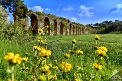
Pictures of Dalaman – Mugla / Turkey
Where is Dalaman