Karadedeli Historical Ruins TOWARDS MERSİN
There are historical ruins from the late Roman and early Byzantine periods along the asphalt road extending from the front of the Karadedeli Village mosque, located at the 13th kilometer from Silifke to Mersin, to İmamlı village towards the north-west. These are:
Karakabaklı
It is north of Karadedeli and 7 km away. There are ruins of a large city spread over a wide area. On the stone paved road passing through the ancient city, the city entrance gate from the early Byzantine period and the ruins of the houses and churches on both sides of the road can be seen.
Isikkale
On the same road, 1 km after Karakabaklı, there are ruins of a basilica, sarcophagus, cistern and randomly planned single-storey houses from the early Byzantine period in good condition.
Sinekkale
It is 1 km after Işıkkale. There are dense old buildings. Especially the Byzantine ruins are still standing. Near 700 m, there is a natural pit with a mouth diameter of approximately 100 m and a depth of 60 m, which can be reached by a path. The interior of this sinkhole, called the Lower World, was inhabited for various purposes in ancient times.
Susanoğlu (Corasium)
The ancient name of Susanoğlu, which is a holiday resort today, at the 15th kilometer of the Silifke – Mersin highway, is Corasium. The city, dating back to the late Roman period, was founded by Flavius Uranius (367 – 375), governor of Isauria.
The inscription found on the western main entrance gate of the city, which was once completely surrounded by walls, reads as follows: “While our princes were living under the administration of Valentinian, Valens and Gratian, Flavius Uranius, the famous ruler of the Isauria province, had this deserted place built according to his own taste, at his own expense.”
There are ruins of two separate necropolises, churches, baths and cisterns in the arch-shaped ancient city around an old bay. Fearless King Mausoleum (Mezgit Kale)
Paslı is reached at the 10th kilometer of the road going north through Susanoğlu. Many houses, cisterns and grave ruins from the Roman period and a necropolis can be seen in Paslı. 3 km east of Paslı, on a small hill, there is the Fearless King Mausoleum. Known as Mezgit Kale by the local people, İ.S. II. century or III. This mausoleum dating back to the Roman period is very well preserved.
The mausoleum overlooking the Mediterranean is 7.80 m in size and there are consoles in the middle of the Corinthian-style titled columns at the front. We understand from the foot holes on the middle two of these consoles that the tomb once contained statues. The same types of consoles are also seen in the actual burial chamber, four in number. A shield in the middle of the rear pediment of the mausoleum; There are sword and scorpion reliefs on both sides.
The most important feature of the tomb is the phallus relief carved on the side wall stone of the front podium. The phallus reminds us of the myth of Priapos, the god of procreation and life. A cistern cut from the rock measuring 5x20x8 m around the mausoleum and giant stone cylinders used to extract olive oil are other ruins that can be seen. Tekkadın
After Paslı, 4 km away, you reach the Tekkadın ruins, where there are extensive ruins from the Roman and Byzantine civilizations. Rock tombs, sarcophagi, sarcophagus lids with lion statues, necropolis, cistern, a small castle, church and dozens of house ruins can be seen here. Following the same road, after Gökburç and Hançerli towers, you reach the Silifke – Uzuncaburç highway. Narlıkuyu (Porto Calamie)
Narlıkuyu Bay, 20 km away from Silifke, is famous for its fish restaurants. The bay, which was a sea gate for those who came to visit and worship in Heaven and Hell during the ancient and Christian periods and was called Porto Calamie in the Middle Ages, has an old bathhouse. From this bath, only the water pool and the floor mosaic in the bathing section remain. Poimenios Bath and the Three Graces.
The bath, located right on the seashore in Narlıkuyu Bay, dates back to the Roman period of the 4th century. It is known that it was built by Poimenios, an influential person in the imperial administration. Three demigoddess sisters are depicted on the floor of the bathing section of the bath, which was built here by making use of the fresh water source where the underground stream in the paradise sinkhole reaches the sea.
In the mosaic, whose dominant colors are white, black, brown and yellow, Zeus’ daughters Aglaia, Euphrosyne and Thalia are seen dancing naked among doves and partridges. The Turkish version of the Greek text on the upper edge of the mosaic painting is as follows: “O guest friend! If you are wondering who found this miraculous water and brought its hidden source to light, know that it is Poimenios, the friend of the emperors and the honest ruler of the Holy Islands.”
As can be understood from the inscription, Poimenios was a friend of the Roman emperors Arcadius and Honorius and the ruler of today’s Büyükada, Kınalıada and Heybeliada at that time. At the 2nd kilometer of the asphalt road heading north from Narlıkuyu, the place where the ancient city ruins and caves are located is reached.
Among the building ruins from the Roman and Byzantine periods, there are still standing door jambs and stone arches, a cistern, and the Temple of Zeus right next to the Heavenly Sinkhole. Zeus Temple and Church.
This temple, which served in three different periods, was built as a symbol of the victory of Zeus, the father of the gods, against the giant dragon Typhon. The names of 130 religious and statesmen who served during the Hellenistic and Roman periods were engraved on the stones to the east of the northern side wall. In the light of this information, it can be thought that the temple was built in the late Hellenistic or early Roman period.
It was completely destroyed during the Christian period and turned into a church with its own stones. The church, whose name and when it was built is unknown, dates back to the 4th century at the earliest; It dates from the 5th century at the latest. Paradise Collapse.
It is a large pit formed as a result of the ceiling collapsing due to chemical erosion caused by an underground stream. The diameters of the ellipse-shaped mouth are 250 m and 110 m, and the depth is 70 meters. At the southern end of the collapsed floor, there is a large cave entrance, 200 m long and 135 m at its deepest point, and a small church at the mouth of this cave.
In the 4-line inscription on the entrance door of the church, it is written that this church was built in the 5th century by a religious person named Paulus, dedicated to the Virgin Mary. You can go down into the heavenly cave via a stone staircase with 452 steps, each quite wide. The church is reached at the 300th step. The sound of a mythological underground stream is heard at the end of the cave after the church. Hell Pit.
The Hell Pit, 75 m north of the Heaven Pit, was also formed like the Heaven Pit. The mouth circle diameters are 50 m and 75 m, and the depth is 128 meters. Since its edges are concave, it is not possible to go down inside. According to mythology, after Zeus defeated the flame-spewing hundred-headed dragon Typhon in a fight here, he imprisoned him in the pit of Hell for a while before sealing him under the Etna Volcano forever. Asthma – Wishing Cave
It is 300 m southwest of the Cennet sinkhole. It is accessed by a spiral iron staircase. The interconnected galleries, with a total length of 200 meters, are decorated with very interestingly shaped giant stalactites and stalagmites. Its interior is illuminated and it is called Asthma-Wish Cave because it is believed that it is good for asthmatics and wishes are made inside. The average temperature in the cave is 15 degrees Celsius, and the humidity reaches 85% in summer and 95% in winter.
People who visit this place make wishes and tie pieces of cloth to the tree and bush branches around the caves of Heaven and Hell and the Asthma-Wish Cave. Adamkayalar
At the 5th kilometer of the asphalt road from Kızkalesi to Silifke’s Hüseyinler Village, you reach the Devil’s Creek valley at the end of the two-kilometer stony road branching off to the west. On the steep slope of this valley, in 9 niches on the rocks, I.S. II. There are reliefs of 11 men, 4 women, two children and a mountain goat dating back to the 1st century BC. A Roman eagle relief can be seen on the pediments of some niches. Cambazlı Church
After Adamkayalar, you pass through Hüseyinler Village and arrive at Cambazlı Village. It is understood that Cambazlı was an important settlement center during the Hellenistic, Roman and Byzantine periods, as it is connected to Uzuncaburç (Diocaesarea), Ura (Olba) and Kızkalesi (Corycus) by an ancient road and the rich ruins that have survived to the present day.
Here, in addition to the rock tombs, mausoleums resembling small temples, sarcophagi, cisterns and especially the church at the entrance of the village are historical ruins worth seeing. Cambazlı Church is one of the best preserved examples among its counterparts that has preserved its original features. Of the two columns inside the building, whose northern façade is completely closed, all columns with Corinthian capitals on the right and the gallery columns above them are still standing.
The apse and all walls of the 20 m
When you turn right at the 4th kilometer on the Taşucu road and travel one kilometer, you reach Meryemlik, one of the oldest and most important centers of Christianity. The history of Meryemlik begins with the arrival of Azize Tekla. One of the disciples of Jesus Christ, St. Impressed by Paul’s sermons, 17-year-old Tekla devotes herself to Christianity. St.
While this valuable student of Paul was making propaganda to spread Christianity in Konya and Yalvaç, when he learned that he would be subjected to pressure from the pagans and killed, he escaped to Seleucia and hid in a cave that was later converted into a church. While he spreads the Christian faith against the polytheistic religion to the local people from the cave where he took shelter, he also heals the sick by performing miracles. It is believed that he got lost in this cave when he was about to be killed again.
The cave in which Aya Tekla lived was considered sacred by Christians after her disappearance; until this religion A.D. It was used as a secret place of worship until it was released in 312. This cave was later built in IV. It was converted into a church in the century.
Apart from the Cave Church in Meryemlik, which was adorned with many structures in the periods after the official acceptance of Christianity, the St. Thecla Church, of which only a part of the apse remains standing on this cave today; The church built by Emperor Zenon dedicated to Hagia Thecca and the North Church; Baths, many cisterns, cemeteries and city wall ruins have survived to the present day. Taşucu (Holmi)
At the location of Taşucu, at the 10th km of the Silifke – Antalya highway, BC. VII. No historical artifacts remain from the old Holmi colony, which was founded in the 16th century. Holmi existed for a long time, but due to pirate attacks, B.C. IV. It started to weaken after the century.
Seleucus Nicator, one of the commanders of Alexander the Great and the founder of the Syrian Kingdom, took advantage of the weak situation of the city and easily captured it; He settled his people where today’s Silifke is located. Taşucu, which is the most important gate between Türkiye and TRNC in terms of passenger traffic, is rapidly developing as a modern tourist resort today.
There are building ruins from the late Roman and early Byzantine periods at the ancient Mylai ruins, which the locals call the Monastery, on the southern slope of a hill 2 km west of Taşucu. Liman Castle.
It is right next to the Taşucu – Antalya highway and by the sea. The castle, 7 km away from Taşucu, is an Ottoman structure and was built in the 14th century. It was built in the century. It is one of the few destroyed castles remaining to this day. Boğsak Island (Nesulion)
On Boğsak Island in Boğsak Bay, there are houses, tombs, cisterns and church ruins from the Roman and early Byzantine periods. Tokmar Castle (Castellum Novum)
Tokmar Castle, which can be reached by a 5 km asphalt road branching off to the north at the 22nd kilometer of the Taşucu – Antalya highway, was built on a hill overlooking the sea. There are defensive bastions in the north of the castle, which is surrounded by a steep rock to the south. XII. It is estimated that it was built in the century BC. Cilician Aphrodisia
This ancient settlement, popularly known as the Ovacık Peninsula and referred to as Cilician Aphrodisia in the archaeological literature, can be reached via a secondary road branching off to the south at the 35th kilometer of the Silifke – Anamur highway. B.C. XII. The cyclopean city walls and bastions, which are estimated to have been built in the 16th century and whose total length is approximately 4 kilometers, are the oldest ruins that can be seen. The most important work of the ancient city is St. Pantaleon Church. WORK. IV.
The floor of the church, dating back to the 19th century, is completely covered with mosaics. The mosaic floor, decorated with geometric shapes, plant and bird motifs, is very well preserved. Knight’s houses, cisterns and necropolis are other ancient ruins that can be seen. TOWARDS KONYACyprus Peace Operation Martyrs Memorial Forest
A Memorial Forest was created in Çamdüzü location, at the 5th kilometer of the Silifke – Gülnar road, in memory of the 454 officers, non-commissioned officers, non-commissioned officers and privates who were martyred in the Cyprus Peace Operation. In the Martyrdom, which was completed in 1976 and covers an area of 9 hectares, there are the Atatürk Monument and the ceremonial area and the symbolic graves of our martyrs around it. A tree was planted next to each grave.
In the martyrs’ cemetery, there is also a monument commemorating the 220 Turkish Cypriot Mujahideen Martyrs. Some of the Greek tanks, cannons, armored vehicles and weapons captured in the 1974 Cyprus Peace Operation are exhibited here. Frederik Barbarossa Monument
Roman – Germanic Emperor Frederik Barbarossa, III. He drowned in the Göksu River near Ekşiler Village on June 10, 1190, while he was going to Palestine with his army during the Crusade. The monumental stone, which was dedicated to the place where Frederik Barbarossa was drowned by the German Embassy in 1971, is on the right side of the road at the 9th kilometer of the Silifke – Konya highway. DIRECTIONS TO KIROBASIDemircili (Imbriogon) Mausoleums
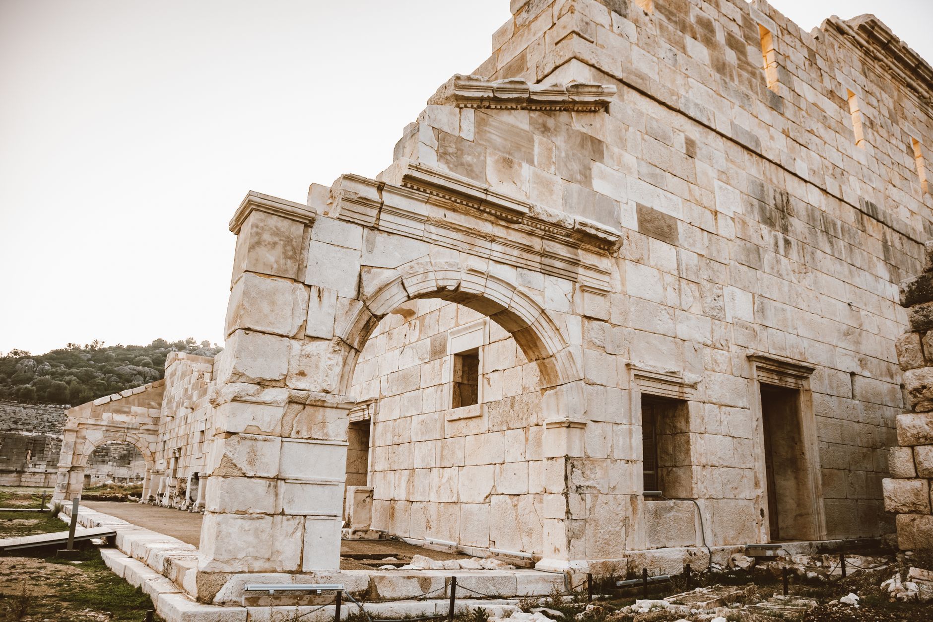
At the 10th kilometer of the Silifke – Uzuncaburç highway, there are single and double-storey mausoleums belonging to the nobles of the ancient city of Imbriogon. The mausoleums, four of which are located right next to the road, date back to I.S. II. century Roman period ruins.Uzuncaburç (Diocaesarea)
The most important and best-preserved historical ruins of İçel are in the town of Uzuncaburç, 30 km north of Silifke. Today’s Uzuncaburç settlement, which was the place of worship of the Olba Kingdom, 4 km east of Uzuncaburç, the center of which was located in the Hellenistic era, was built in the Roman period, AD. In 72, during the reign of Emperor Vespasian, it was separated from Olba and became a new site called Diocaesarea (God-Emperor City), which was autonomous and could mint money in its own name.
Temple of Zeus in Diocaesarea, mausoleum with bastion and pyramid roof, Seleucids, that is, Hellenistic; The colonnaded street, theatre, ceremonial gate, fountain, Temple of Chance and Victory Gate are structures dating back to the Roman period. With the development of Christianity in the region in the 5th century, the Temple of Zeus was converted into a church, and new churches were also built. After the Byzantine period, Anatolian Turks named this place “Uzuncaburç” after the high bastion that was the symbol of the city.
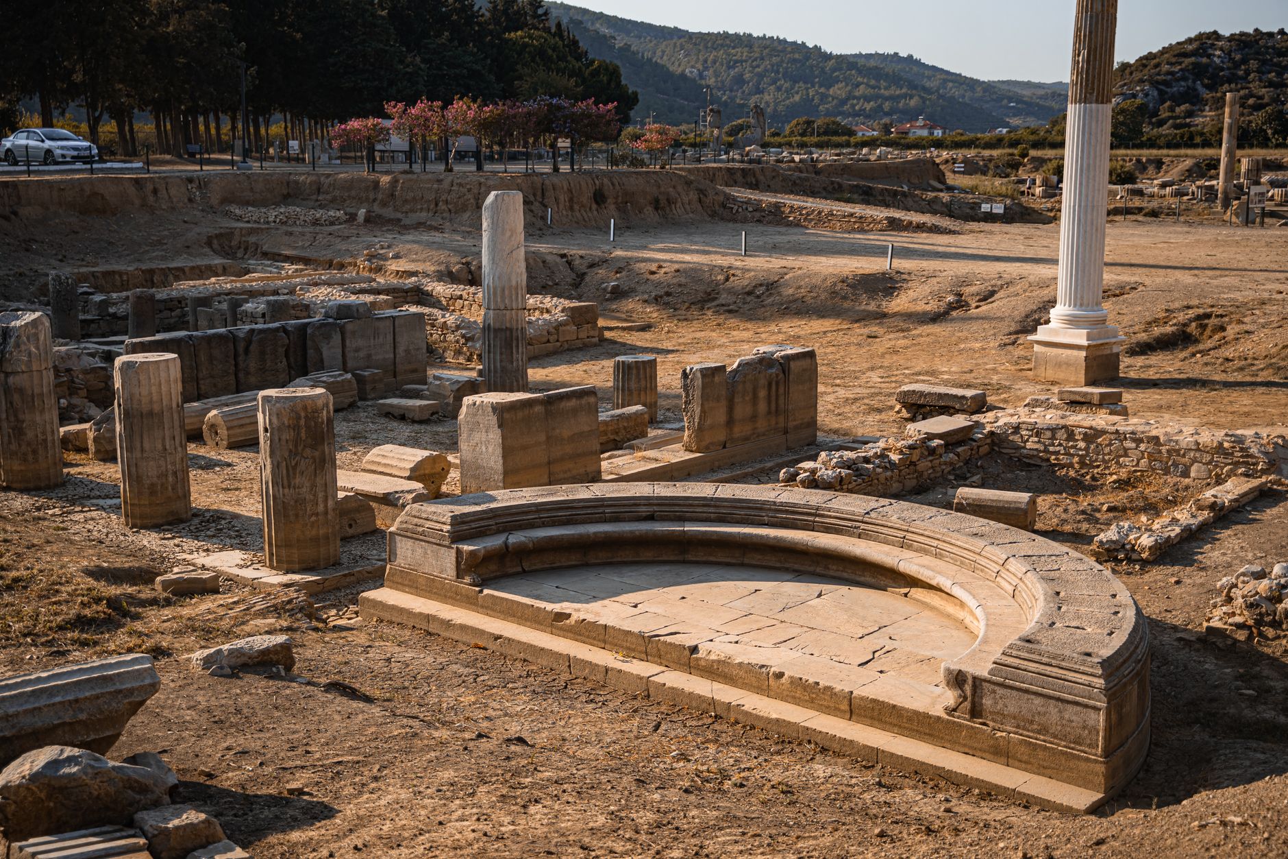
The main ruins in Uzuncaburç are: Columned Street. The columned street passing in front of the theater intersects with another columned street coming from the city gate next to the Temple of Zeus and ends at the Temple of Chance. WORK. All of the columns on the Colonnade Street, dating from the 1st century, were destroyed and most of the architectural pieces were destroyed. Ceremonial GateAD. I.
The Ceremonial Gate, dating back to the 16th century, is an imposing structure with columns with Corinthian capitals, each 1 m in diameter and 7 m in height. There were statues at the time on the consoles protruding from the column bodies. 5 columns of the Ceremonial Gate, half of which was destroyed, are still standing.
It is thought to have been built by 312 – 295). The Temple of Zeus has an important place in art history as one of the oldest temples in Anatolia, with a Peripteros plan in the Corinthian style, surrounded by 36 columns in a single row on all four sides. The temple, which was also used by the Romans, was built during the Christian period, V.
In the century, it was converted into a church with significant changes; The cella was demolished, the spaces between the columns were built up and doors were placed there, and the columns in the east were removed and an apse was added in their place. The Temple of Zeus, more than two thousand years old and with its magnificent appearance today, still stands, defying the passing of time. Temple of Luck (Tychaeum) The Temple of Chance, at the end of the columned street, was built in I.S. It was built in the second half of the 1st century.
The inscription on the architrave carried by 6 monolithic granite columns, five of which are standing today and are 6 m high, states that the temple was built by Oppius, one of the nobles of the city, and his wife Kyria, and was gifted to the city. Victory Gate: Located on the second columned road in the south-north direction and in the north of the Temple of Zeus, there is a large one in the middle of the gate; It has two small arched entrances on the sides.
The inscription on it states that the door, which was damaged in the earthquake, was significantly repaired during the joint rule of Roman Emperors Arcadius (395 – 408) and Honorius (395 – 423). It is understood that there were statues and busts on the consoles in various parts of the monumental gate in the past.
This magnificent structure, which looks like a “Triumphal Arch”, is known as the Gate of Triumph. It is understood from an inscription found here that it was built during the joint rule of Roman Emperors Marcus Aurelius (161 – 180) and Lucius Verus (161 – 169).
A naturally hollow land was chosen as the location and the seating steps were built by taking advantage of the slope of the land. Hellenistic Mausoleum, built on a hill in the south of Uzuncaburç town, is unique in the region with its Doric architecture. The 15 m high tomb with a pyramid roof has a square plan measuring 5.5 m x 5.5 m.
It is estimated that the 2300-year-old mausoleum belongs to one of the rulers of the Seleucids or Olba Kingdom. Hellenistic High Tower. Located on the northeastern edge of the walls surrounding the city, the 5-storey tower is 16 m x 13 m in size and 23 m high and no mortar was used in its construction.
The tower, each floor of which was divided into sections, was used not only as a place where administrators lived, but also as a safe place where people took shelter in case of danger and where the city treasury was protected. From the inscription on the tower door, BC. III. The tower, which was understood to have been built by Tarkyares in the 2nd half of the century, was destroyed by the order of the governor Petronius as a result of a fire in AD. III. It was repaired in the late century.
This observation and shelter tower, which was used as an emblem on old coins, was the source of the name of today’s town due to its height: Uzuncaburç. Churches With the arrival of Christianity in the region, three more churches were built in the 5th century, apart from the church converted from the Temple of Zeus. These are the Stefanos Church near the tower, the Cemetery Church in the necropolis and a small church next to the theatre.
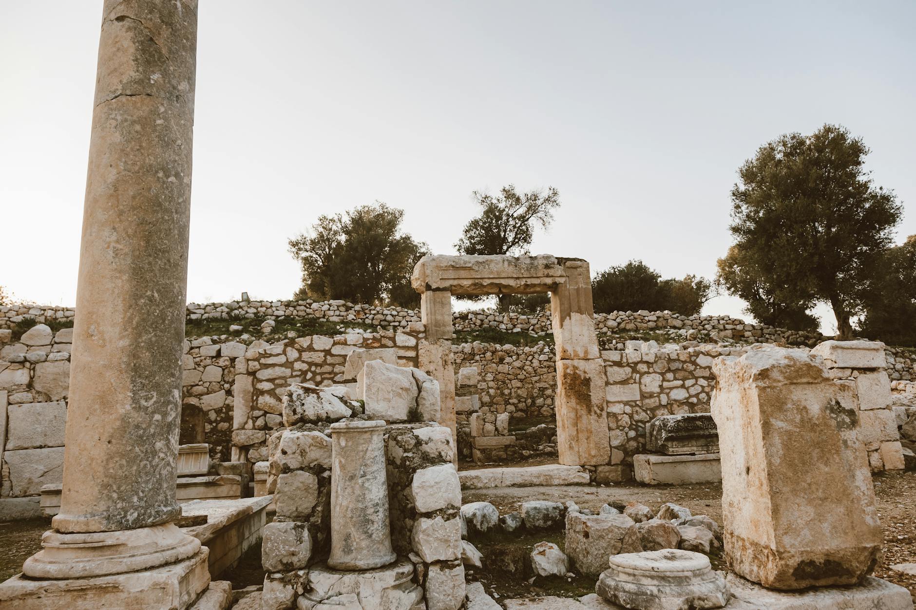
There are very few remains of these. Necropolis The necropolis area, spread on both slopes of a valley in the north of the city, was used in both the Hellenistic, Roman and Byzantine periods and there are many rock-carved tombs. Ura (Olba)
Ura, 4 km east of Uzuncaburç, was the center of the Olba Kingdom and an important trade city during the Hellenistic period. Among the ruins that have survived from the ancient city, which was built on a hill, are a fountain building, aqueduct, houses, theater and necropolis. The fountain building, one of the most important works here, was built by Septimus Severus (AD.
193 – 211) The water taken from the Lamus Creek was flowed into this fountain through channels, tunnels and aqueducts. Another important work is the four-arched aqueduct, 150 m long and 25 m high, built on the valley where the necropolis is located. The fact that towers were built to protect this aqueduct and monitor the environment shows the importance of the structure. The aqueduct, which was built in the same period as the ancient fountain, was built by Byzantine Emperor II.
It was repaired in 566, during the reign of Justin. Some seating steps and a part of the stage from the theater building next to the fountain have survived to this day. Rock tombs and sarcophagi can be seen in the very large necropolis area of the city of Olba.
You May Like

Aspendos Ancient Theater Travel Guide