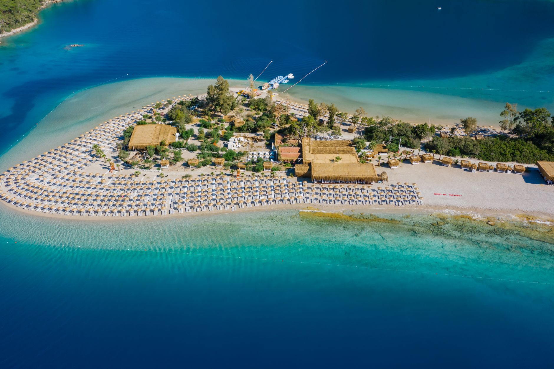
As a result of dune movements, the 600-meter strip that starts from the land and divides the bay into two is called Kızkumu. Various legends are told about the formation of this road, which also serves as a natural breakwater:
In ancient times, the daughter of the king of those places and a fisherman fell in love with each other. However, the world situation was valid at that time, the king’s daughter could not reach the fisherman. Moreover, the father who said this is the King! That being the case, the girl and the boy meet secretly, of course… The king father finds out about this over time and makes his daughter follow him one night.
They say that the fisherman is coming from the sea, your daughter is waiting for him on the beach, he points to where she is with the light, then the young man comes to the light and your daughter and the young man are playing love games with each other until the sunrise… Hearing these, the king gets angry. The king kills even if it is his daughter who opposes his orders. One night, he catches his daughter and tells his soldiers to send a signal to the fisherman on the beach with a light.
When the young man sees the light, he jumps into his boat and runs into a squad of soldiers… The girl escapes from the hands of the soldiers and starts running to save her loved one, but it is impossible to reach the other end of the bay… But this is love, she does not listen to rules, she throws herself into the water… At that moment, a miracle happens!
Everywhere the girl steps turns into a beach, and the soldiers chasing after her sink into the sea with all their weight as they press on… The girl can run to the boat, but an archer targets the young man at that moment and waves his arrow… Alas! The girl and the young man are already hugging each other and that arrow comes and meets the girl… They say that those sands were dyed red when the girl’s blood mixed with the sea… The young man takes the girl and leaves, then no one sees or hears…
Baybassos (Orhaniye=Kızkumu)
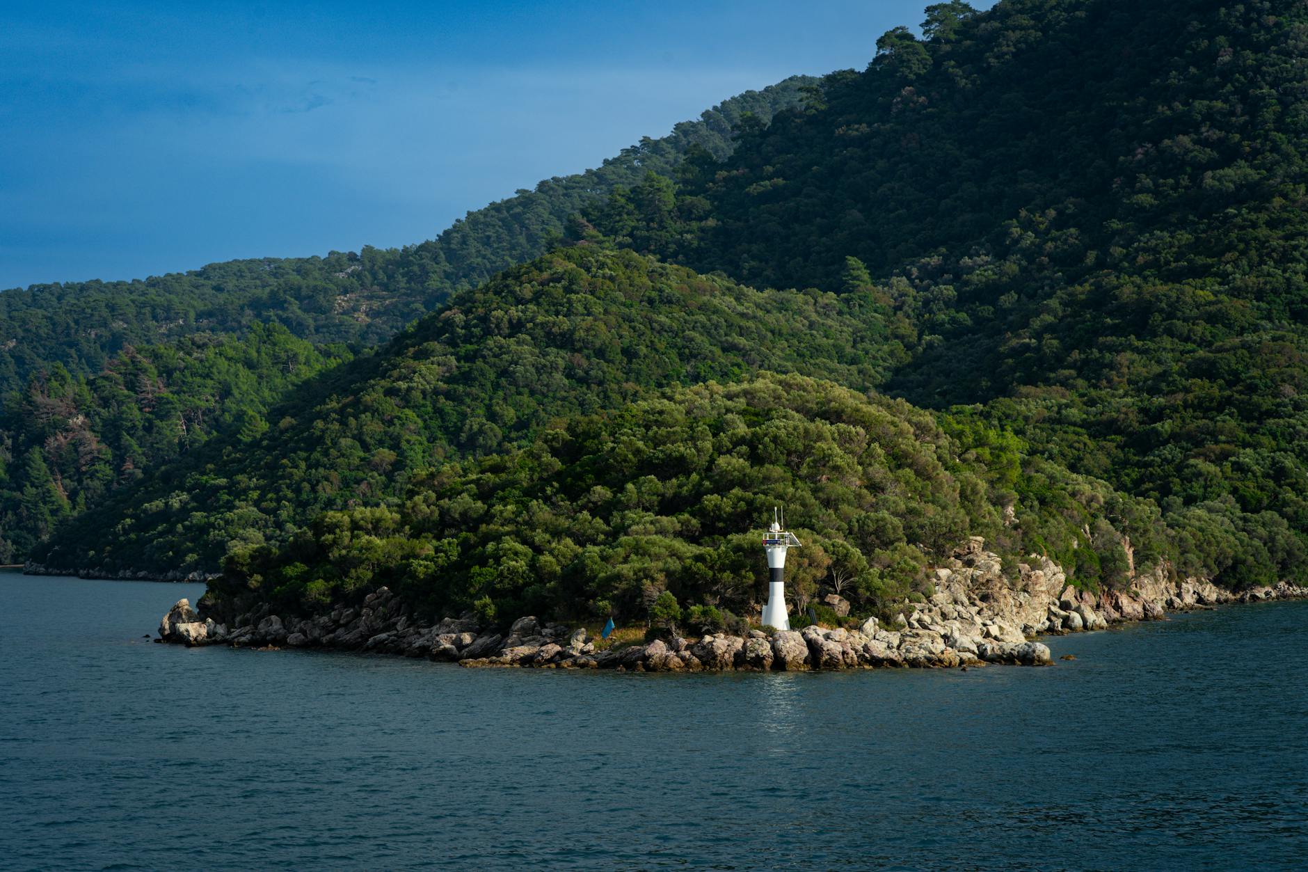
One of the most important tourism centers on the coast of Hisarönü Gulf is Orhaniye. Yachts coming to Hisarönü Bay always spend the night in Orhaniye. The sea is always smooth in Orhaniye. The color of the surrounding pine forest hit the water, giving the sea a color unique to this place. The environment is so calm that when you immerse yourself in the water, you hear nothing but the sound you make while swimming.
Meanwhile, people walking in the middle of the sea will attract your attention. You will be surprised. As a result of dune movements, a shallow was formed starting from the land and dividing the bay into two. The approximately 600-meter strip is called Kızkumu. There is also a legend. Wanting to escape from the pirates chasing her, the girl put sand in her skirt and walked across the sea. But the sand was not enough and the girl drowned. There is an island in the middle of the bay and castle ruins on top of the island.
It is thought that the castle belongs to the ancient city of Baybassos located in the region. You can go to the island by boat and follow the path to the castle ruins on the hill. The view is wonderful. It will be worth your tiredness. The people of Baybasos brought water to the castle from the waterfall in Turgut village through arches and underwater pipes. They took advantage of the combined containers rule.
The ruins of Baybassos, a Carian city, are located on one of the peaks of the mountain on which Orhaniye stands. You can reach the village near Baybassos by car. To find the way, it is necessary to get help from the surrounding villagers. Because, like in most ancient cities, there are no direction signs here. The way out is dirt and bumpy. The vehicles are left in the village and the summit is reached after a 45-minute climb through the forest.
The view below, covering a wide area from Selimiye to Hisarönü, is quite impressive. A boat tour is also organized from Orhaniye to Hisarönü Bay. There is a break in bays such as Selimiye, Hisarönü and İnbükü and the island of Dışlice. The tour continues until the evening. Located on a hill overlooking the Gulf of Hisarönü, the island of Dışlice, just across from the Robinson Club Maris hotel, attracts attention with its small canyons and rock structure.
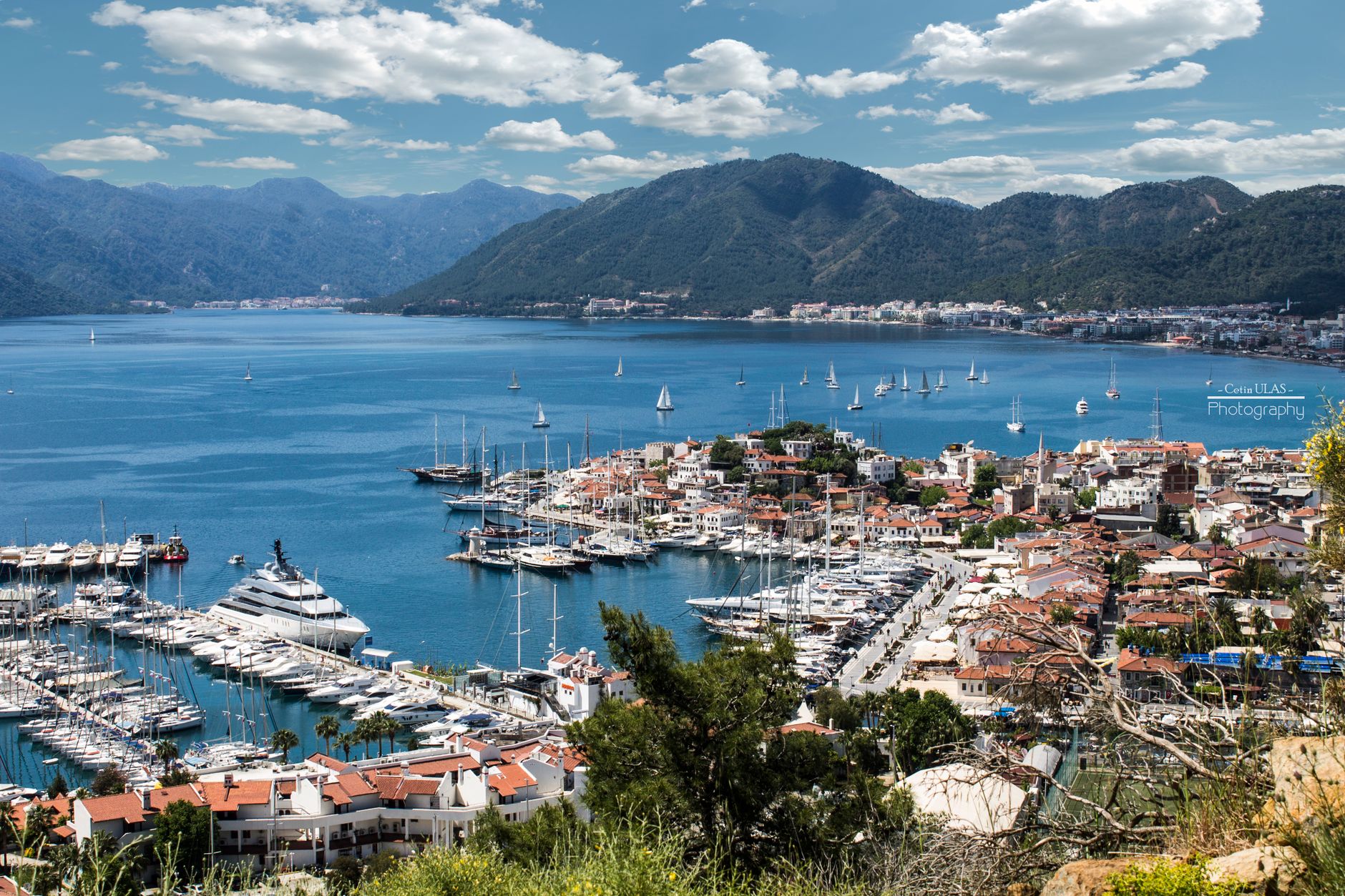
There are monastery ruins next to the Bay Marina Hotel, located at the entrance of Orhaniye Bay, Keçi Bükü location, where yachts stay. The mosaics in the garden are worth seeing. The hotel is still under construction, but its restaurant and yacht dock are active. It is also possible to go from Orhaniye to Hisarönü and the Marmaris-Datça road. The distance between Orhaniye and Hisarönü is only 3.5 km. The road is wide and asphalt.
Turgut
Turgut, the first village after Orhaniye, is a village that started to develop thanks to tourism. The largest carpet sales stores around Marmaris are at the entrance of Turgut. The carpet and souvenir shops, where tourists come in groups and shop, have created a great liveliness in the village. There is also a small pyramid tomb on the hillside at the exit of Turgut village.
Waterfall
Just after passing Turgut village, you will see the Şelale sign. It is possible to go to the waterfall location, 200 meters from the road, by car using a dirt road. The waterfall is not one of those grand waterfalls we know. It was formed by a stream flowing from a height of 3-4 meters, flowing through dense vegetation throughout the valley and whose water decreases significantly in the summer months. The water of the stream is ice cold.
If you have your swimsuit with you, you can swim in the pond created by the waterfall, which is 2-3 meters deep, and get rid of the sweltering heat for a short time. There are pergola restaurants around and next to the waterfall. The pancakes and ayran cooked on the spot by the village women will be good after a cold shower. If you wish, you can also order trout and chicken. If you can spare time, you can walk along the stream and into the valley.
But keep in mind that dense vegetation makes walking difficult at times.
Selimiye
From Orhaniye, we head towards Bozburun by following the asphalt road along the coast. The road is wide and asphalt. We are in Selimiye, 10 km after Orhaniye and 7 km after the Turgut junction. Selimiye is one of the stopping points of blue cruise boats sailing between Bodrum and Marmaris. The village is surrounded by greenery. The sea water is clean and generally calm, but it does not have a beautiful beach. Small restaurants gathered by the pier usually serve the boats.
An endless tranquility dominates the surroundings. It is announced to those who want to have a holiday away from the crowds. There are also historical ruins around Selimiye. There are three castle ruins around Selimiye, whose ancient name was Hydas. One is on the highest hill of Selimiye, the other is on Sarıkaya hill, and the last one is Aşarkale in Kızılköy neighborhood. The Hellenistic period city wall ruins on the southeastern hills of the bay are visited.
The watchtower built 100 meters off the coast to guide boats approaching Selimiye, the lighthouse, the monastery and the theater are other ruins of the city worth seeing. The remains unearthed from the shipwrecks in the region are exhibited in the Bodrum Underwater Museum. If you are looking for a beach in Selimiye Bay, which is a natural harbor where boats take shelter in stormy weather, you can go to the shallow harbor with sparkling sand two km away.
Bozburun
Bozburun is mostly known by yachtsmen. It is one of the most untouched places in the region in terms of tourism. Because, as its name suggests, it is a grey, treeless region. Recommended for those who want a quiet holiday. There are no large facilities. You can find small but quality facilities. It is located in one of the bays of the Symbeki Gulf. The surroundings are unusually bare compared to other parts of Marmaris.
It has a PTT, small hotels, hostels and good fish restaurants. They say the best gulets are built here. Gulet races are also held. There are many quiet bays around which can be reached by boat.
Willow
Söğüt village can be reached from Bozburun or Bayır village. Söğüt village is at the extreme and somewhat remote point of the Bozburun peninsula. For this reason, it has remained significantly out of tourism traffic. Despite this, the village market is very lively. Villagers are aware of tourism, they try to help and show interest. The village is inland from the sea. Söğüt’s gateway to the sea is Saranda Bay. Saranda, which is 3 km away from Söğüt, can be reached by a dirt road.
An impressive view will greet you when you land in Saranda. Sömbeki Gulf and the green Saranda Bay are under your feet. The big island ahead and in the fog is Greece’s Symi Island. Enjoy this view, especially at sunset.
Saranda (Bozukkale=Loryma)
If you want to reach the ancient city ruins of Bozukkale and Loryma, where boats from Marmaris to Bodrum stop, by land, you have to drive from Söğüt to Taşlıca and then walk. The ruins of the ancient city are at the entrance point of the bay, among the maquis, and are in very good condition. There are three restaurants in Bozukkale bay, which generally serve blue cruise boats and yachts.
Farm
You can go to Çiftlik via Bayır. There is a vague sign inside the Bayır. After a slight climb, the descent towards Çiftlik Bay begins. At this point, where you will see Çiftlik Bay on one side and Hisarönü Bay when you turn back, rest for a while and fill your lungs with the clean mountain air. Pine forest all around. The farm is accessed via a slightly winding road. You are on the beach in 15 minutes.
The coarse sandy beach of Çiftlik Bay attracts the most attention. It is worth adding that the sea is always crystal clear. Immerse yourself in cool water. Swim for a long time and then lie down on the sand. Sand is not the kind that gets dirty and doesn’t come off. The beach surrounding the bay is not very crowded except for the noon hours when the daily boats coming from Marmaris stay. But despite everything, the old calm of Çiftlik Cove is no longer there.
There is a small island at the entrance of Çiftlik bay. The island is private property and cannot be entered without permission. Let us note that the rocks on both sides of the bay are suitable for diving, but it is now very difficult to find fish for spearfishing.
Bayır
Bayır Village has become a popular stopping point for jeep safari tours in recent years. Don’t forget to take a break and drink tea or sparkling ayran at one of the open cafes under the giant-sized historical plane tree in the village square. Its wisdom is unknown, but it is said that taking a tour around an old plane tree prolongs life. The people of Bayır wrote this on the nameplate of the plane tree and hung it.
Knidos
Knidos is a historical and ancient place located at the extreme point of the Datça Peninsula. At this point you can see both the Mediterranean and the Aegean Sea. Transportation: When you take the Knidos turnoff just before Datça, you reach Knidos after 35 km. You can also come with daily tours. The most valuable work unearthed here to date is the “NAKED APHRODITE” statue. This statue is the world’s first naked goddess statue.
At that time, only god statues were naked, goddess statues were half-naked. Knidos also has an interesting story. In ancient times, a leprosy epidemic broke out in Greece, and many people were infected with this disease. In order to prevent the disease from spreading further, Greek authorities put leprosy patients on ships and took them away from Greece and left them in this region at the tip of the Datça Peninsula.
A long time passes and Greek officials come to see what happened to the lepers they left behind. And they see that all the lepers were healed, started families and increased their population, and even founded a city (Knidos) and started to live in this region. Greek officials are very surprised. It is said that the reason for the healing of these lepers is Datça’s beautiful, clean air and sea, and its atmosphere that gives health and happiness.
Cedar Island
The road turning left at the 12th km of the Marmaris-Muğla road takes you to another point of Gökova Bay, Çamlı Pier, after 6 km. As the boats fill up from Çamlı Pier, they go to Sedir Island. Sedir Island is known for the ancient city of Cedreae (Kedrai) and the famous Cleopatra Beach. The narrative about Cleopatra, told from the golden sands of the island, is just an exaggerated touristic tale.
The most common narrative is that Queen Cleopatra and her lover, Roman Commander Antony, were brought from Egypt by ships to meet on the island. The sands on the northern coast of the island are specially formed limestone droplets and are seen only on the island of Crete, apart from Sedir in the Aegean and Mediterranean. Unfortunately, these sands are not adequately protected and are being plundered. The sands that emerge as a result of very special geological formations are gradually decreasing.
Despite this, Cleopatra beach continues to attract the attention of visitors with its golden sand and sea reflecting different shades of blue. The boats return to Çamlı pier between 4 and 5 in the afternoon.
You May Like

Aspendos Ancient Theater Travel Guide