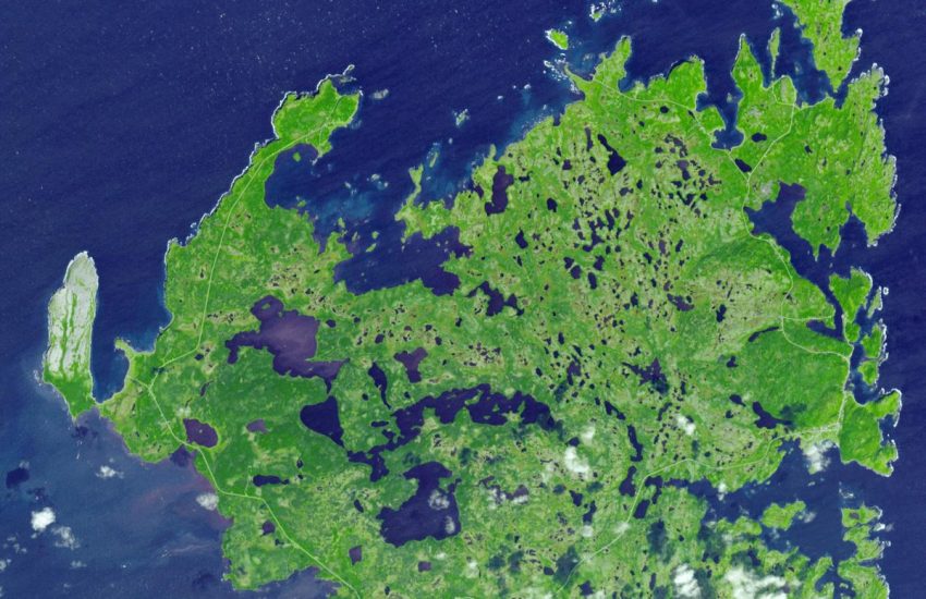
Known as Ushtogaysky Square, it is the first and largest discovered in Kazakhstan. (Image: Digitalglobe, via NASA)
Two weeks ago, the National Aeronautics and Space Administration NASA published satellite images of giant geoglyphs in the steppes of Kazakhstan, taken from an altitude of 700 km. Approximately 260 geometric figures, squares, crosses, lines and circles, whose shapes can only be understood when seen from the air, have been found in the steppes of Kazakhstan since 2007.
NASA added the ‘Steppe Geoglyphs’, about which little is known, to the mission list of the International Space Station astronauts to photograph them from space. The largest of the geoglyphs was found next to a Neolithic settlement dating to between 6,000 and 10,000 years ago. This landform consists of a giant square consisting of 101 hills. Opposite corners of the square are also connected with diagonal lines.
This landform covers an area even larger than the Pyramid of Cheops. Another geoglyph consists of a three-armed swastika with zigzags on each arm. Geoglyphs in the form of hills, ditches and embankments found in the Turgay region in northern Kazakhstan were described as unique and previously unstudied at an archeology conference held in Istanbul last year.
Dmitry Dey, a Kazakh economist and archeology enthusiast, discovered the shapes in satellite images in the Google Earth program in 2007. “I’ve never seen anything like this before, and I found it extraordinary,” said Compton J. Tucker, a senior biosphere scientist at NASA, who provided NASA’s archival photographs to the New York Times and Dey.
Ronald LaPorte from the University of Pittsburgh, who helped promote the discovery and findings, said NASA’s interest is very important in providing assistance for future research. Dey found the landforms by chance, after watching a documentary about pyramids, while browsing through Google Earth thinking there might be pyramids in Kazakhstan.
Dey, who first found the square shape made of dots and with diagonal lines inside, initially thought that this might be a device left over from the Soviets. But as he found more geoglyphs in the following days, his opinion changed. The number of shapes, which was 19 in 2012 and has now reached 260, includes hills, ditches and embankments.
Before examining the figures on site, Dey asked the Kazakh archaeologists if they were aware of these figures, but received a negative answer. In August 2007, he went to the area where the largest geoglyph (now known as Ushtogaysky Square) is located, together with 3 archaeologists from Kostanay University. “It is very, very difficult to understand the shapes from the ground. The lines go towards the horizon,” Dey said.
“You can’t understand what the shape is,” he said, but he completely rejected the strange alien theories and said, “I don’t think the shapes were made to be seen from the air.” he says. Dey says the shapes may have been for sun observation purposes, like the Chankillo towers and Stonehenge in Peru. “The shapes may be horizontal observatories built to monitor the movements of the sun,” says Dev, adding, “Everything is connected to the sun cult.”
Bestamskoe Apartment. (Image: Digitalglobe, via NASA)
“I was afraid it was made up,” says Epidemiology professor LaPorte, who saw reports of the findings while researching diseases in Kazakhstan. LaPorte reached Dmitry Dey through the Ministry of Foreign Affairs.
When the accuracy and importance of Dey’s images and documents became apparent, Kazakhstan’s Space Agency, KazCosmos, was contacted to access more images, and local governments were contacted to urgently take the areas under UNESCO protection. But no result has been reached yet. Archaeological Studies on Mysterious Figures
The Turgay steppes were rich lands preferred by Stone Age hunter-gatherers looking for hunting grounds.
Dimitriy Dey’s research shows that the older shapes may belong to the Mahandzhar culture, which lived in this region between 7000 BC and 5000 BC. But scientists are amazed at the possibility of a nomadic society staying in the same place for the long periods it would take to build earthen structures of such a large size.
It was necessary to cut timber, place it, and excavate lake bed sediments to build the hills and embankments, which today are about 1 meter high and 12 meters long, and when first built they were 3 meters high. Persis Clarkson, an archologist from the University of Winnipeg, said the figures were similar to geoglyphs in Peru and Chile and changed ideas about nomads.
“The idea that foragers could assemble the large numbers of people needed to accomplish such large-scale projects has caused archaeologists to rethink the nature and timing of large-scale human organization.”
Turgay Swastika consists of a three-sleeved swastika with zigzags on each sleeve. (Image: Digitalglobe, via NASA)
Cambridge University archaeologist Giedre Motuzaite Matuzeviciute, who visited two of the figures, said that great efforts had indeed been made to construct the figures.
Dr Matuzeviciute, who introduced the figures with archaeologists Andrey Logvin and Irina Shevnina at the European Association of Archaeologists conference in Istanbul, said he was skeptical about calling these figures “geoglyphs” because geoglyphs “describe art, not objects that have a function.” Nothing other than the materials used to construct the figures has been found in the two hills excavated so far.
Dimitriy Dey said, “These were not graves or mausoleums with items in them, we did not find anything.” But recently, spearheads and other artifacts were discovered at a Neolithic site dating to between 6,000 and 10,000 years ago. Dr. Matuzeviciute dated the building materials using an optically stimulated luminescence technique and dated one of the mounds to 800 BC.
While other preliminary studies put the date at 8,000 years ago, other materials dated to the Middle Ages. “We cannot dig all the hills, this would be counterproductive. Instead, we need modern technologies like in the West,” says Dimitri Dey. Dr Laporte said the option of using drones was being considered, similar to what the Peruvian Ministry of Culture does to preserve and map archaeological sites.
But Dey also reminds us that time is an enemy. Dey explains that a figure called the Koga Cross was destroyed during road construction, although local authorities were notified. Source: http://arkeofili.com/?p=8215
You May Like
Norse Explorers Reached Canada 500 Years Before Columbus