Kemer, which is 35 km away from Antalya, was a small village until the early 80s. It made a name for itself with the rise of tourism. The fully equipped Kemer marina is prepared for yachtsmen to explore the excellent bays and beaches in the south of the town.
In the spring, yacht races are organized between Kemer and the port of the Turkish Republic of Northern Cyprus and Kyrenia.
Its history can be considered in parallel with the history of Antalya.
There are ancient cities in this region, such as Phaselis and Termessos, that are partially still standing. The foundation of these cities is mainly based on the Rhodes and Cretans who escaped from Doric oppression in the 6th and 7th centuries BC.
Alexander the Great came to this region in B.C. We know that he came in the 330s. Hellenic age A.D. It continues until the 1st century. And then comes the Roman period.
The closest ancient city to Kemer is Phaselis. Here M.S. We know that Hadrian, the greatest Emperor of the period, came. Research on Kemer does not provide information beyond the fact that this place is a Lycian City. However, according to the information obtained from the local people, Kemer, which was called Old Village in the 1910s, took on the appearance of a lake and a swamp due to the floods coming from the mountains.
Later, in 1916-1917, the people living here moved 23 km to the foothills to protect themselves from floods. They built a long stone wall. Because of this wall, it was later called Kemer.
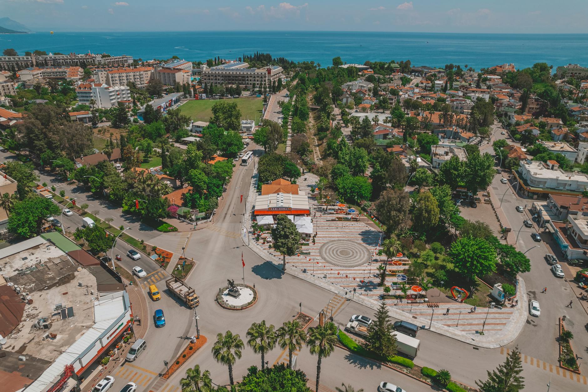
At the foothills of the Western Taurus Mountains, 43 km from Antalya. distance and 52 km. Our district, which extends along the coastline, is one of the most important tourism centers in Turkey. In the 1910s, where Kemer is located today, there was a settlement known as Old Village, which consisted of lakes and swamps as a result of floods coming from the mountains. To protect themselves from these floods, the people of Old Village lived 23 km away at the foot of the mountains.
They built a long stone wall and later called their village Kemer because of this wall.
Since there was no highway until the 1960s, Kemer was only accessible by sea, and after 1980, it developed and grew and became one of the most popular tourism centers in Turkey. One of the main attractions of Kemer is its natural beauty. Sea, forest and mountains come together at one point. The historical structures of our region include Phaselis Ancient City, Çıralı Yanartaş, Seljuk Hunting Lodge and Idyros Ancient City.
Since there was no highway until the 1960s, Kemer was only accessible by sea. It developed rapidly by gaining road and other infrastructure values within the scope of the South Antalya Tourism Project implemented after 1980, and today it has become one of the most popular tourism centers in Turkey.
Kemer district and settlements such as Kiriş, Tekirova, Çayova, Aslanbucak, Kuzdere, Beycik, Çamyuva, Göynük, Beldibi, Çıralı have an extremely important place in Antalya tourism.
One of the main attractions of Kemer is its natural beauty. Sea, forest and mountains come together at one point. The clarity of the sea, the greenery of the forest, the sea waves reaching up to the pine trees, and the use of pine trees as shade on the beaches are very attractive. The entire coast, starting from Beldibi location to Tekirova, is a completely natural beach.
Municipality beach in the center of Kemer and Moonlight beach next to the marina. It is possible to swim easily in places such as Phaselis beach. It is also possible to benefit from the pools and beaches of the accommodation facilities for a fee. It is possible to reach the nearby ancient cities of Olympos and Phaselis from Kemer. In recent years, safari tours to high places such as Söğüt Cuması, Altınkaya and Dere Köy have attracted a lot of attention.
Additionally, other attractions in the region are caves.
These caves: Beldibi cave is on the seashore, 27 km southwest of Antalya. There are also prehistoric ruins. Another cave worth seeing is Molla Hole. It is located on the eastern slope of Tahtalı Mountain, which rises to the west of Kemer. It is possible to reach this cave only on foot from the villages of Aşağı Kuzdere or Tekirova on the Kemer – Kumluca highway. It takes 3 to 4 hours to walk from both villages.
The construction of sports fields continues in Kemer. There are sports facility units within the facilities. There are multi-purpose sports facilities complexes in the South Antalya Development Project. There are also water sports and diving opportunities. The area starting from Antalya Trade Port to Çavuş (Adrasan) Town is the “Olympos Bey Mountains Coastal National Park”.
In this region, there are daily picnic areas and recreational facilities such as Topçam, Çaltıcak, Beldibi, Göynük, Kındıl Çeşme, Alacasu, Paselis, Olympos. There are also water sports and diving opportunities. The area starting from Antalya Trade Port to Çavuş (Adrasan) Town is the “Olympos Beydağları Coastal National Park”.
In this region, there are daily picnic places and rest areas such as Topçam, Çaltıçak, Beldibi, Göynük, Kındıl Çeşme, Alacasu, Phasellis and Olympos. Kemer people generally go to higher areas such as Gödene Plateau (Altınyaka), Yeşil Plateau (Söğüt Cuması), Üçoluk Plateau and Belen Plateau during the summer months.
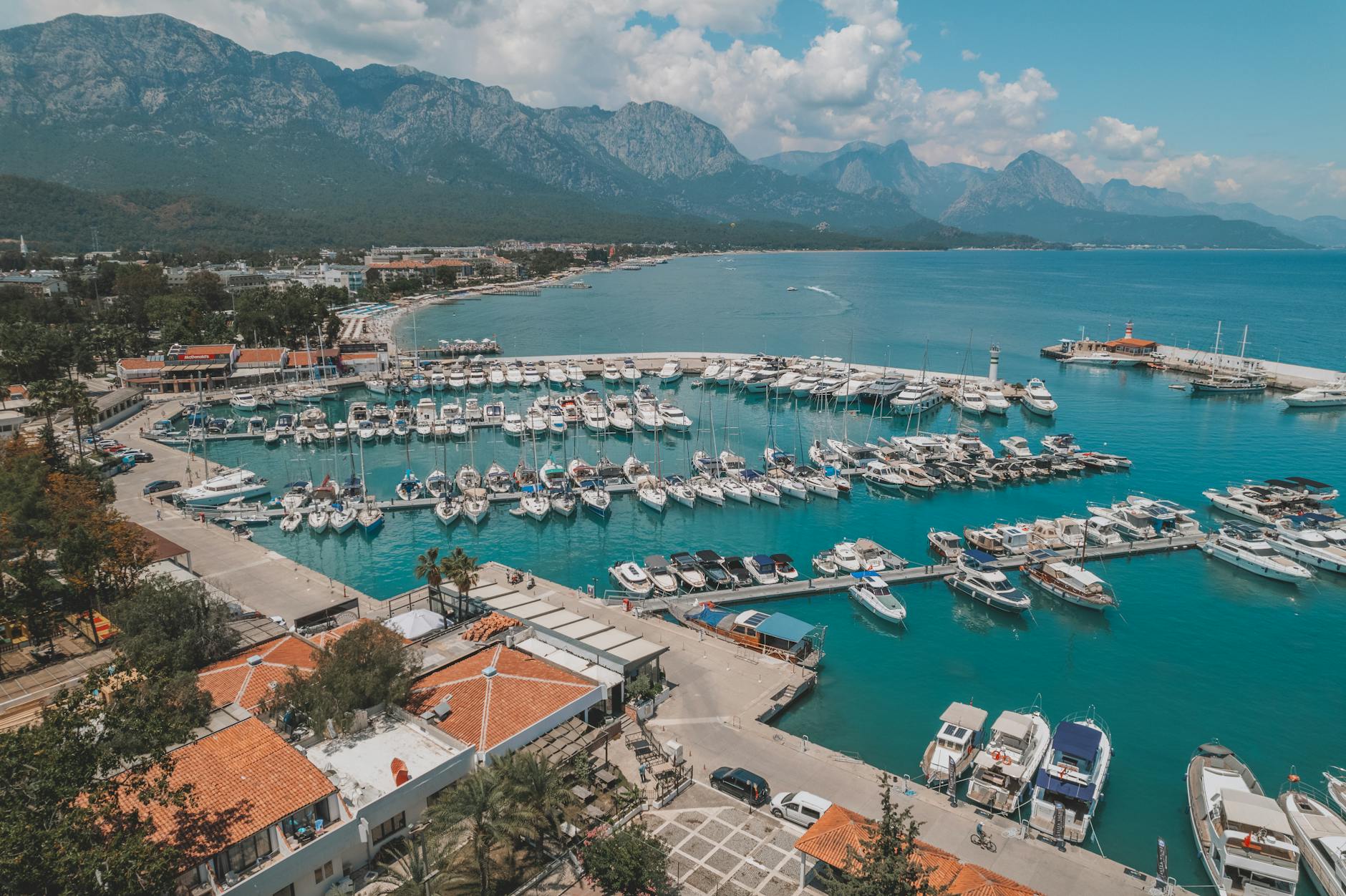
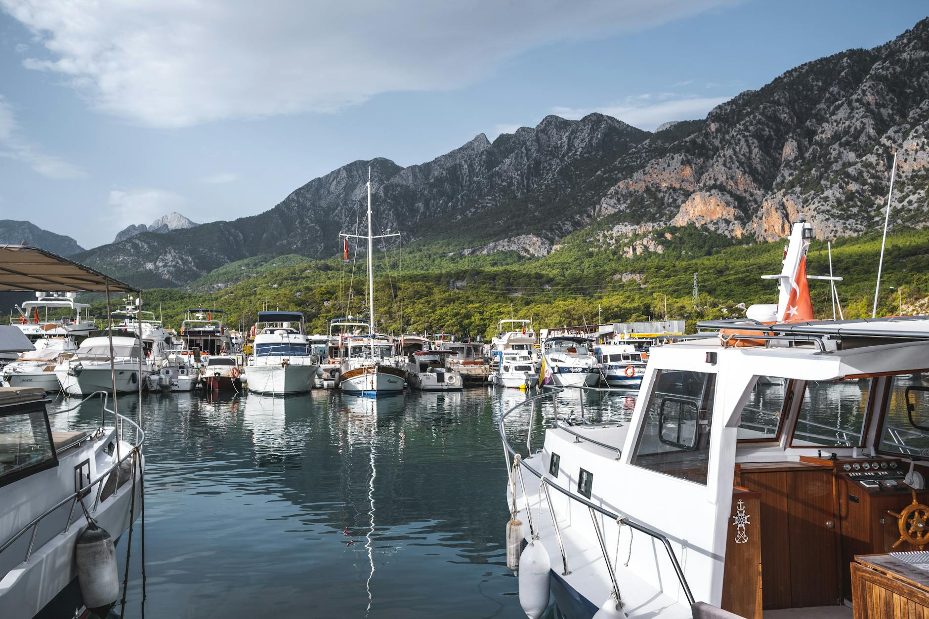
Söğüt Cuması is located on the Taurus Mountains and the Yeşil Yayla, Oil Wrestling, which is very famous in the summer months, has become traditional. Kemer has an important place in terms of Yacht Tourism. It is a center for yachts from various countries in summer and winter. Incoming yachts stay here for a day or for a long time.
The marina (Park Marina), which was officially put into operation with all its service units in April 1986, has a capacity of 300 yachts, 100 on land and 200 at sea, and provides 24-hour service with various units. Kemer Marina was awarded the Blue Flag in 1993 by meeting the criteria determined by the Blue Flag Campaign carried out by the European Environmental Education Foundation (FEEK).
In addition, in the Kemer region, Kemer (Central) Tekirova, Göynük, Beldibi, Çamyuva and Kiriş beaches have also been awarded the Blue Flag. Daily tours are organized from Kemer to the surrounding bays. Generally, on such a trip in the Lycia region, the first trip is to Phasellis and after the visit, you can continue to Olympos. Additionally, “Blue Cruise Tours” can be made starting from Kemer and Antalya.
Fishing is done as amateur fishing with small boats. Angling is usually done.
OLYMPOS – BEYDAĞLARI NATIONAL PARK
Starting from Antalya Port, Beydağları National Park includes the coastal slopes of the Beydağları and extends to Cape Gelidonya. With its large and small bays and natural beaches, one side contains the Beydağları National Park, which repeats the cool call of the sea blue, and the other side contains the green freshness of the forest rising from the Mediterranean, sometimes with a rough and steep slope and sometimes with a gentle slope.
The vegetation, which starts with stone pines on the seashore, turns into red pine, larch and cedar trees as it rises, and turns into a natural treasure of great value for wildlife.
OLYMPOS – CIRALI
It is between Kemer and Adrasan in the west of Antalya. After passing Phaselis on the Antalya-Kumluca road, there are two signs showing the roads leading to Çıralı and Olympos. Olympos can be reached by both ways. Çıralı is the name of the village next to the ancient city of Olympos. Olympos B.C. It is a port city founded in the 2nd century. WORK. It preserved its existence until the 15th century. The famous Bellerophontes legend took place here.
The ancient city is on both sides of a uniquely beautiful valley. Where the valley and the city reach the sea, the sand forms a very beautiful beach. Çıralı, which can be reached in an hour on foot from Olympos, is an interesting natural wonder. On this mountain, which the locals call “Yanar”, the flames created by the natural gas leak and burning for thousands of years rise to the sky.
We recommend that those who come here for the first time go to Yanar with a guide from Çıralı Village.
ARCHAEOLOGICAL TEXTURE OF THE REGION
Not enough information has yet been obtained about the ruins found during the excavations carried out between 1976 and 1977. Claiming that the ancient city of Idyros was located in this region, Carl Ritter writes that the city was north of Phaselis, on the northern slope of Cape Kapawawa.
However, the research carried out by Antalya Museum experts in 1977 confirmed another researcher, Kipert, that the city was located on the southeastern coast of Kemer Mountain, in the bay where An Awawa Cape is located. Another different opinion is that of Prof. Head of the Department of Ancient Languages and Cultures from Akdeniz University. Dr. It comes from Sencer Şahin.
Şahin claims that the Ancient City of Olbia, which was thought to be located in Antalya Arapsuyu until today, was actually located in the Kemer region and that the view that the ruins found here belong to the city of Idyros is a complete misconception. Prof. Dr.
According to Sencer Şahin, the Ancient City of Idyros should be sought in today’s Çamyuva location. Regardless of its name, the ruins of an ancient city in Kemer can be found today, offering archeology and history enthusiasts its beauty full of secrets along the coast.
CHURCH The church, which was found during excavations and is thought to belong to the Byzantine period, dates back to B.C. It dates back to the 4th – 7th centuries and features a complex structure with a chapel in the south, a baptisterium in the north and other structures around it.
KEMER / OLBIA – ÇAMYUVA / IDYROSProf. Dr. Sencer Şahin, Head of Department of Ancient Languages and Cultures, Faculty of Science and Literature, Akdeniz University. Olbia, one of the famous cities of Pamphylia, has always been searched in the wrong place, in the Arapsuyu area just west of Antalya, due to the lack of a good understanding of written ancient sources. However, the famous scholar Aristotle (Ps.
Aristotle) writes in his book “The Formation of the Winds”, “A strong wind called Idyreus blows in Olbia.”
Aristotle’s student Theophrast, in his book titled “About the Winds”, clarifies the information given by his teacher a little more and says: “The wind named Idyris, which blows in the morning, blows violently from the river valley called Idyros and mixes with the South and Southeast winds (at sea).” The Idyros River mentioned in these sources is today’s Ağva Stream.
As it is known, this stream passes through a narrow rock cleft called Kesme Boğazı, whose eastern end opens to the Bey Mountains, and flows into the sea near Kemer. Therefore, in order for the wind called Idyris coming from the Idyros Valley to blow in the city called Olbia, Olbia must be in a location where this valley opens to the plain. The most suitable place for this recipe is Kemer.
Not only is it directly related to the Kesme Strait in terms of its location, but it is also in complete agreement with the information about Olbia given by the famous geographer Strabon from Amasya. According to Strabon, Olbia is 67 km from Cape Gelidonya. It was both a port and a fortified castle, far to the north, on the seashore. And the cape where the castle was located formed the natural border between Pamphylia and Lycia.
Likewise, the place that best fits this description is the Classical-Hellenistic Age castle ruins on Çalışdağ Hill in Kemer, surrounded by cliffs on three sides. There is a threshold that limits Olbia. We witness that the city expanded from Çalışdağ Hill towards the plain during the Roman and Byzantine ages.
This is proven by both Roman and Byzantine sources and the ruins of bridges, temples, churches and necropolis from these ages in Kemer. Until today, it was thought that Kemer could be the ancient city of Idyros, but this is also wrong. Because, according to the information we have obtained from ancient sources, Idyros was built in B.C. It is a city that disappeared from the stage of history in the 3rd century, that is, 2300 years ago.
That is why it is natural that we cannot find traces of this city on the land today. However, according to the information we have obtained from many ancient sources, Olbia lived through both the Roman and Byzantine ages. This clearly shows that Olbia should be in Kemer and Idyros should be in today’s Çamyuva.
You May Like

Aspendos Ancient Theater Travel Guide