Rising directly out of the dense rainforest canopy of northern Guatemala’s Petén region, the steep temple pyramids of Tikal remain among the most instantly recognizable ruins in the entire ancient Maya world. Their tall, narrow silhouettes, capped with elaborate roof combs and often glimpsed poking above an unbroken sea of green jungle, have made Tikal a symbol of the Classic Maya civilization at its most architecturally ambitious.
Tikal’s occupation stretched across an unusually long span of Maya history, from modest Preclassic beginnings before the fourth century BCE through its peak as one of the most powerful cities in the Maya lowlands during the Classic period, and finally into decline and abandonment by the tenth century CE, a history covering well over a thousand years of continuous settlement in one location.
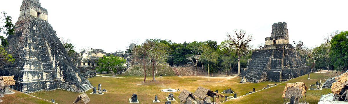
Table of Contents
- Arriving in the Heart of the Petén Rainforest
- Nearly a Thousand Years of Continuous Power
- Temple I: The Tomb of Jasaw Chan K’awiil
- The Teotihuacan Connection: A Foreign Entrada in 378 CE
- What Language Did the Rulers of Mutul Speak?
- The North Acropolis: A Royal Necropolis Centuries in the Making
- Twin Pyramids and the Ritual of Counting Time
- Reservoirs, Causeways, and a City Engineered for Water
- Decline and the End of Classic Tikal
- Rediscovery and Visiting Tikal Today
- Nearby Places to Explore
- Closing Thoughts
Arriving in the Heart of the Petén Rainforest
Reaching Tikal today still requires genuine effort, with most visitors flying into the nearby town of Flores before making a further overland journey into Tikal National Park, a protected area covering the ruins and the surrounding rainforest that UNESCO recognized as a mixed cultural and natural World Heritage site in 1979, honoring both the archaeological significance of the ruins and the exceptional biodiversity of the forest that has grown up around and through them.
The Great Plaza forms the ceremonial heart of the site, flanked on its eastern and western sides by Temple I and Temple II, two steep, narrow pyramids facing one another across an open ceremonial space that has hosted royal ritual, public ceremony, and dynastic commemoration for well over a millennium of Maya history.
Beyond the Great Plaza, a network of ancient causeways connects the ceremonial core to outlying temple complexes, including Temple IV, which at nearly seventy meters remains among the tallest pre-Columbian structures ever built anywhere in the Americas, its summit offering visitors a genuinely rare view across an unbroken expanse of rainforest canopy with the roof combs of other Tikal temples emerging here and there above the treeline.
Wildlife sightings are practically guaranteed for visitors willing to explore beyond the main plazas, since the surrounding national park protects one of the largest remaining tracts of undisturbed rainforest in the region, and howler monkey calls echoing across the ruins at dawn have become almost as iconic a part of the Tikal experience as the temples themselves.
Nearly a Thousand Years of Continuous Power

Unlike many Classic Maya cities that rose and fell within a few centuries, Tikal’s ruling dynasty, known by its emblem glyph as Mutul, maintained political importance across an extraordinarily long stretch of Maya history, with a documented royal lineage stretching from the Late Preclassic period through the final recorded rulers of the ninth century, making it one of the longest continuously documented royal dynasties anywhere in the ancient Maya world.
This longevity did not mean uninterrupted dominance. Tikal experienced serious military setbacks, most notably during its long rivalry with Calakmul and Calakmul’s allied cities to the north, a conflict extensively documented through hieroglyphic inscriptions at both capitals and covered in greater detail in this site’s article on Calakmul itself, including a period during the sixth century sometimes called Tikal’s hiatus, when the pace of monument construction and royal inscription slowed dramatically following military defeat.
Tikal’s eventual recovery from this low point, culminating in a decisive military victory over Calakmul’s ally Naranjo in 695 CE under the ruler Jasaw Chan K’awiil I, marked the beginning of the city’s final and most architecturally productive period, during which its rulers commissioned the tallest and most elaborate temple pyramids the city would ever produce.
Epigraphers have reconstructed an unusually complete dynastic list for Tikal’s Mutul kingdom, naming dozens of successive rulers across the centuries, a level of documentation that owes much to the sheer volume of carved stelae and monuments the city’s kings commissioned throughout its long history, particularly during its final centuries of peak power.
Alliances and marriages between Tikal’s royal family and those of subordinate or allied cities throughout the Petén region formed a critical part of how the Mutul dynasty projected influence beyond the city’s immediate core, a diplomatic strategy documented through genealogical references carved on monuments at multiple satellite sites throughout the surrounding lowlands.
Temple I: The Tomb of Jasaw Chan K’awiil
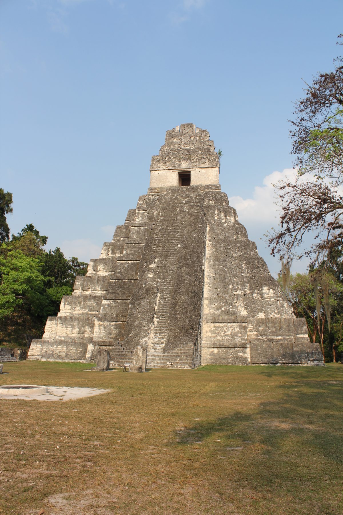
Temple I, also known as the Temple of the Great Jaguar for a carved wooden lintel depicting a jaguar found within its summit shrine, was built as the funerary monument of Jasaw Chan K’awiil I, the king whose military victory over Naranjo restored Tikal’s regional prominence after generations of reduced influence.
Rising in nine steep tiers to a height of roughly 47 meters, Temple I’s proportions, narrow and dramatically vertical compared to the broader, lower profile typical of earlier central Mexican pyramids, exemplify the distinctive architectural style Tikal’s builders perfected during the Late Classic period, prioritizing dramatic visual height over the wider ceremonial platforms favored elsewhere in Mesoamerica.
Excavation of the tomb beneath Temple I in the 1960s revealed an extraordinarily rich royal burial, including jade ornaments, ceramic vessels, and carved bone artifacts inscribed with hieroglyphic texts, confirming the structure’s identification as Jasaw Chan K’awiil’s own funerary monument and providing archaeologists with one of the best-documented royal Maya burials anywhere in the lowlands.
The carved wooden lintels found inside Temple I’s summit shrine, made from extremely durable sapodilla wood, represent some of the best-preserved wooden artifacts to survive from the entire ancient Maya world, since organic material rarely endures the tropical climate long enough to reach modern archaeologists intact.
Comparisons between Jasaw Chan K’awiil’s tomb goods and those recovered from royal burials at other major Classic Maya cities, including Palenque’s own famous royal tomb, help archaeologists trace shared elite burial customs and trade networks connecting distant Maya courts despite the political rivalries that frequently divided them.
The Teotihuacan Connection: A Foreign Entrada in 378 CE
Among the most debated episodes in Tikal’s long history is the arrival, in 378 CE, of a figure named in inscriptions as Siyaj K’ak’, meaning Fire Is Born, whose appearance at Tikal coincides with the sudden death of the reigning king and the installation of a new ruler, Yax Nuun Ahiin I, closely associated in surviving texts with a powerful figure called Spearthrower Owl, whose name and iconography carry strong stylistic connections to distant Teotihuacan in central Mexico.
Archaeologists and epigraphers have debated for decades whether this event represents an actual military conquest of Tikal by agents connected to Teotihuacan, a more limited diplomatic or dynastic intervention, or some combination of both, but the material evidence is unambiguous: Teotihuacan-style architecture, ceramics, and warrior imagery appear abruptly at Tikal following this event, in a pattern too widespread and too sudden to represent simple gradual cultural exchange.
Whatever the precise political mechanism, this so-called entrada connected Tikal directly into a network of long-distance political and cultural relationships extending all the way to central Mexico, a level of interregional contact remarkable for the fourth century and one that likely contributed significantly to Tikal’s subsequent rise as one of the dominant powers of the Classic Maya lowlands.
Some researchers have proposed that the 378 CE entrada may have involved a relatively small but highly influential group of Teotihuacan-affiliated warriors and administrators rather than a full-scale military invasion, suggesting that even a modest foreign presence could dramatically reshape a Maya royal court’s political alliances and artistic patronage when combined with local political instability.
Ceramic and architectural styles clearly derived from Teotihuacan appear not only at Tikal itself but at several other Maya sites during this same general period, suggesting the political changes associated with the entrada extended their influence considerably beyond Tikal’s own immediate territory, reshaping alliances and artistic conventions across a meaningful portion of the southern Maya lowlands.
What Language Did the Rulers of Mutul Speak?
Tikal’s hieroglyphic inscriptions, like those of Calakmul and Palenque, were composed in Classic Ch’olan, the shared prestige literary language used across Classic Maya royal monuments regardless of the specific spoken language of any individual city’s general population, a convention that again limits how confidently modern linguists can identify Tikal’s actual everyday vernacular language purely from its surviving texts.
Most specialists place Tikal’s likely spoken language within the Ch’olan branch of the Mayan language family as well, given its geographic position within the Petén heartland generally associated with Ch’olan-speaking populations during the Classic period, distinct from the Yucatecan languages that dominated further north on the Yucatan Peninsula at sites like Uxmal and Chichén Itzá.
The Teotihuacan-connected political changes of 378 CE add a further linguistic complication, since any Teotihuacan-affiliated newcomers integrated into Tikal’s royal court would likely have spoken a language entirely unrelated to Mayan, quite possibly an early form of Nahuatl or another central Mexican language, meaning Tikal’s royal court may have functioned as a genuinely multilingual environment for at least part of its history, even if Ch’olan Mayan remained the dominant language of the wider population.
Modern linguistic reconstruction efforts continue to refine our understanding of how Ch’olan and Yucatecan Mayan languages diverged and spread across the lowlands during the centuries before and during Tikal’s peak, work that draws heavily on comparing hieroglyphic texts from Tikal against those from more clearly Yucatecan-associated sites further north on the peninsula.
The North Acropolis: A Royal Necropolis Centuries in the Making

The North Acropolis represents one of the most architecturally dense and historically layered structures anywhere in the Maya world, a platform built and rebuilt continuously across more than a thousand years, with later rulers repeatedly constructing new temples directly atop the accumulated remains of their predecessors’ funerary monuments rather than clearing the space entirely.
Excavation tunnels dug into the North Acropolis by twentieth-century archaeologists revealed a genuine stratigraphic archive of Tikal’s dynastic history, with distinct construction phases corresponding to specific documented rulers, allowing researchers to correlate the archaeological sequence directly with the hieroglyphic historical record in a way rarely possible with comparable precision at other Maya sites.
By the time of Tikal’s final Classic-period peak, the North Acropolis had become so densely packed with earlier temples and royal tombs that later rulers increasingly shifted major new funerary construction to freestanding pyramids like Temple I and Temple IV, effectively treating the original acropolis as a hallowed ancestral space too historically significant to fully redevelop, even as the city’s architectural ambitions grew ever larger elsewhere.
Some of the earliest structures buried deep within the North Acropolis date to the Late Preclassic period, centuries before Tikal’s Classic-period peak, demonstrating that the location held religious and political significance for the city’s rulers long before the more famous temples visible above ground today were ever built.
Tunneling into deeply buried construction phases required archaeologists to work in cramped, poorly ventilated conditions far removed from the open excavation typical of surface work, a genuinely demanding undertaking that nonetheless yielded some of the most historically significant discoveries made anywhere at the site during the twentieth century.
Twin Pyramids and the Ritual of Counting Time
One of Tikal’s most distinctive architectural traditions involved the construction of twin pyramid complexes, paired identical stepped platforms built specifically to commemorate the completion of a katun, the roughly twenty-year period that formed a fundamental unit of the Maya Long Count calendar system, a practice documented at Tikal more extensively than at almost any other Classic Maya city.

Each twin pyramid complex typically included the two matching platforms themselves, a small enclosure containing carved stelae and altars commemorating the specific ruler and calendar date being celebrated, and a range structure on the complex’s southern side, together forming a self-contained ceremonial space used exclusively for these periodic calendar-completion rituals rather than daily religious activity.
This deliberate architectural investment in marking calendar cycles reflects how central precise timekeeping was to Tikal’s royal ideology, with kings using these ritual constructions to publicly demonstrate their role in successfully guiding the city through each major division of sacred time, reinforcing royal legitimacy through repeated, highly visible ceremonial performance tied directly to the passage of the calendar.
At least seven twin pyramid complexes have been identified at Tikal, though not all are equally well preserved, and archaeologists believe additional examples may still await discovery or full excavation, suggesting the actual number commissioned across the dynasty’s history could be higher than currently confirmed.
The carved stelae placed within each twin pyramid complex’s northern enclosure typically depict the reigning king performing specific ritual actions associated with the calendar celebration, providing epigraphers with securely dated portraits that have proven invaluable for constructing accurate chronological sequences of Tikal’s later rulers.
Reservoirs, Causeways, and a City Engineered for Water

Despite sitting within a genuinely rain-rich tropical environment, Tikal faced a real water management challenge, since the region’s porous karst limestone bedrock allows rainfall to drain away quickly rather than collecting in surface rivers or lakes, leaving the city, much like the Puuc region around Uxmal far to the north, dependent on carefully engineered water storage rather than any permanent natural water source nearby.
Tikal’s solution involved an extensive system of plastered reservoirs, several of them created by damming natural depressions and lining them with clay and plaster to prevent water loss through the porous bedrock, capable of storing enough water collected during the wet season to sustain the city’s substantial population through the annual dry season that otherwise left the surrounding forest without reliable surface water.
A network of raised stone causeways, called sacbeob in Mayan languages, connected Tikal’s ceremonial core to outlying temple groups and residential zones, serving both practical transportation functions and likely ceremonial processional purposes, while also helping manage water runoff across the site’s engineered urban landscape.
Engineers studying Tikal’s reservoir system have noted its remarkable capacity, estimating that the largest reservoirs could hold enough water to support the city’s population through even a severe multi-month dry season, though prolonged multi-year droughts, discussed further below, eventually exceeded even this substantial engineered buffer.
Sediment analysis from Tikal’s ancient reservoirs has also provided archaeologists with valuable environmental data, including evidence of periodic contamination and the specific plants and animals present around the water sources at different points in the city’s history, adding an ecological dimension to the broader archaeological understanding of daily life at Tikal.
Decline and the End of Classic Tikal
Tikal’s political and demographic decline during the Terminal Classic period followed a trajectory similar to many other great Classic Maya lowland cities, with the last securely dated monument erected in 869 CE, after which the elaborate court culture that had sustained centuries of monumental construction and hieroglyphic record-keeping appears to have collapsed relatively rapidly.
Researchers generally attribute this decline to a familiar combination of interlocking pressures: prolonged drought documented in regional paleoclimate records, agricultural strain from supporting an urban population that may have exceeded sixty thousand people at its peak, and the destabilizing cumulative effects of generations of warfare with rival powers including Calakmul and its allies.
Unlike some abandoned Maya cities that were entirely forgotten, local Maya communities in the surrounding Petén region appear to have retained at least some awareness of Tikal’s ruins through the following centuries, even as the site’s monumental core gradually disappeared beneath the encroaching rainforest that gives the ruins their distinctive jungle-shrouded character today.
Skeletal evidence recovered from late-period burials at Tikal shows signs of nutritional stress consistent with the agricultural difficulties researchers associate with the broader Terminal Classic collapse, offering direct physical evidence to complement the more indirect paleoclimate and settlement pattern data used to reconstruct the decline’s underlying causes.
A small population appears to have lingered among Tikal’s ruins even after the collapse of centralized royal authority, based on limited evidence of continued, much reduced activity at the site into the Postclassic period, though nothing resembling the city’s former scale or political significance ever returned.
Rediscovery and Visiting Tikal Today
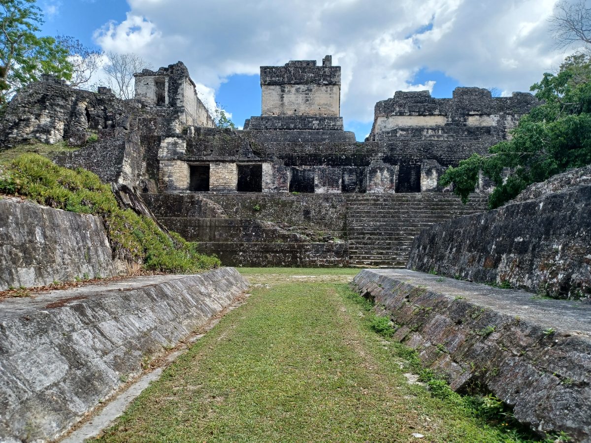
Spanish missionary Andres de Avendano passed near Tikal in 1696 while traveling through the Petén region, leaving one of the earliest written European references to ruins in the area, though it was not until an official Guatemalan government expedition in 1848, led by Modesto Mendez and Ambrosio Tut, that Tikal received the kind of detailed documentation that brought it to wider scholarly attention.
Sustained archaeological investigation began in earnest in 1956, when the University of Pennsylvania Museum launched the Tikal Project, a multi-decade excavation and restoration effort that mapped the site’s causeways, excavated the North Acropolis and Temple I, and established much of the chronological and architectural understanding of Tikal that continues to inform research today.
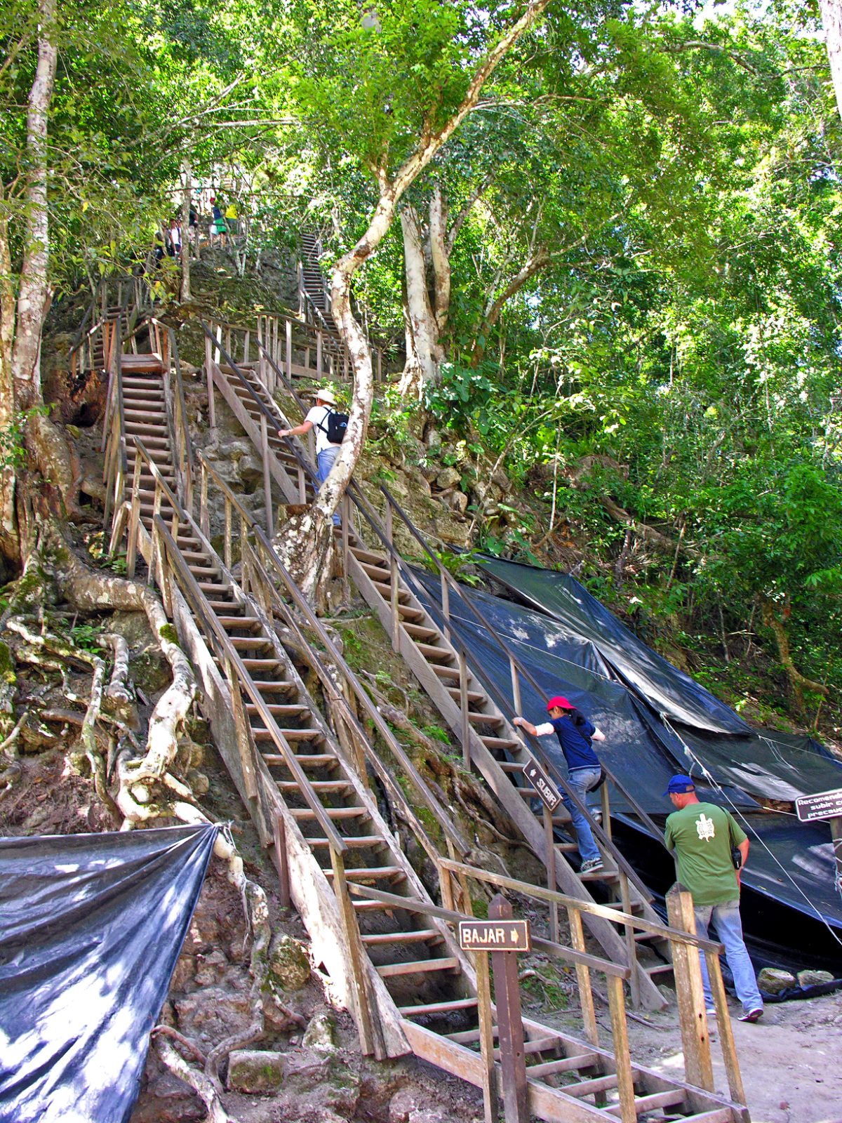
Modern visitors can climb several of Tikal’s excavated temples for sweeping views across the surrounding rainforest canopy, and the park’s protected forest still shelters spider monkeys, toucans, and other wildlife moving freely among the ruins, giving Tikal a genuinely immersive atmosphere that has also made it a popular filming location, most famously providing the exterior shots for a rebel base in the original 1977 Star Wars film.
Lidar surveys conducted across the wider Petén region in the 2010s revealed thousands of previously undocumented structures surrounding Tikal and neighboring sites, suggesting the ancient population of the broader region was considerably larger and the landscape more intensively modified through terracing and causeway construction than earlier ground-based surveys alone had indicated.
Nearby Places to Explore
Tikal’s centuries-long political relationships connect it directly to several other major Maya cities covered elsewhere on this site, each offering useful comparison points for understanding the wider Classic Maya lowland world.
- Calakmul: The Snake Kingdom Lost in the Mexican Jungle
- Copan: The Maya City of Kings and Scribes
- Palenque: The Maya City of Pakal’s Hidden Tomb
Closing Thoughts
Tikal’s remarkable longevity, spanning well over a thousand years of continuous royal succession, gives it a claim to historical continuity matched by few other ancient Maya cities. Its towering temples, engineered water reservoirs, and dense royal necropolis together tell the story of a city that repeatedly reinvented its own political fortunes, surviving military defeat, absorbing foreign influence from distant Teotihuacan, and eventually rising to build some of the tallest pre-Columbian structures anywhere in the Americas.
Standing atop Temple IV today, looking out over an unbroken sea of rainforest canopy broken only by the roof combs of Tikal’s other temples, it becomes easier to understand why this city, more than almost any other Classic Maya capital, has come to represent the ambition and endurance of Maya civilization at its height.
You May Like
Mafra, the Palace a King Built From a Vow


5 thoughts on “Tikal Rises From the Jungle in Towering Maya Temples”